Kesgrave night lights from space
Night Light of Kesgrave (England) from space (United Kingdom) Src. Average luminocity for 10x10km area is 24.9815% and for 50x50km: 5.6058%.
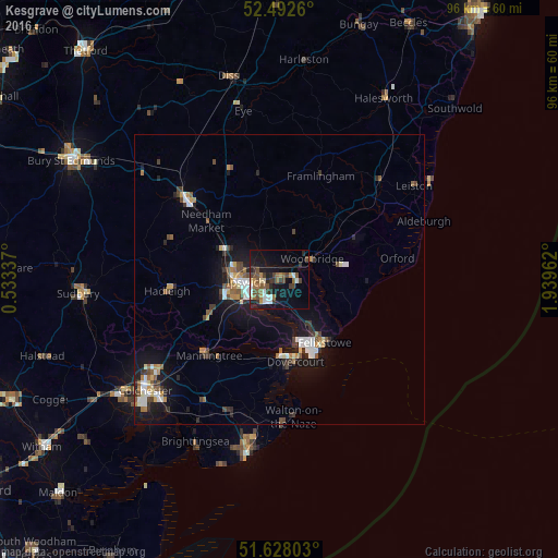
Analysis of Kesgrave night lights 2016
Square area 10x10 km:
 3.17%
3.17%90-99
2.78%80-89
1.98%70-79
2.12%60-69
4.37%50-59
4.63%40-49
6.35%30-39
4.63%20-29
5.42%10-19
19.58%0-9
44.97%Square area 50x50 km:
0.76%90-99
0.87%80-89
0.4%70-79
0.57%60-69
0.71%50-59
0.79%40-49
0.9%30-39
0.8%20-29
1.16%10-19
5.07%0-9
87.98%Clear (daylight) street map image can be seen on geolist.org.
Map coordinates:
52° 29' 33.4" North, 0° 32' 0.1" East
52° 3' 44.7" North, 1° 14' 11.4" East
51° 37' 40.9" North, 1° 56' 22.6" East
Some cities around Kesgrave sort by population:
• Ipswich
5.6 km =3.5 mi,  266°
266°
• Felixstowe
13.5 km =8.4 mi,  144°
144°
• Stowmarket
21.5 km =13.4 mi,  310°
310°
• Harwich
13.8 km =8.6 mi,  166°
166°
• Walton-on-the-Naze
23.9 km =14.9 mi, 174°
• Woodbridge
6.7 km =4.2 mi,  59°
59°
• Hadleigh
19.5 km =12.1 mi,  264°
264°
• Manningtree
17.7 km =11 mi,  222°
222°
6301921 (p: 11,020)
Sources (retrieved 2019-11-25):
» Earth at Night: Flat Maps 2012, 2016