Hadleigh night lights from space
Night Light of Hadleigh (England) from space (United Kingdom) Src. Average luminocity for 10x10km area is 1.6566% and for 50x50km: 6.6296%.
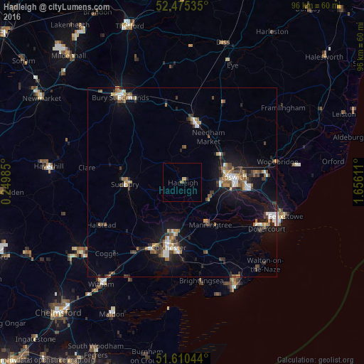
Analysis of Hadleigh night lights 2016
Square area 10x10 km:
 0%
0%90-99
0%80-89
0.25%70-79
0.76%60-69
0.38%50-59
0.13%40-49
0.51%30-39
0%20-29
0.51%10-19
0.38%0-9
97.1%Square area 50x50 km:
0.79%90-99
0.9%80-89
0.5%70-79
0.69%60-69
0.98%50-59
0.89%40-49
1.09%30-39
1.1%20-29
1.3%10-19
5.51%0-9
86.22%Clear (daylight) street map image can be seen on geolist.org.
Map coordinates:
52° 28' 31.3" North, 0° 14' 59.5" East
52° 2' 42" North, 0° 57' 10.7" East
51° 36' 37.6" North, 1° 39' 22" East
Some cities around Hadleigh sort by population:
• Ipswich
13.9 km =8.6 mi,  83°
83°
• Colchester
17.6 km =10.9 mi,  190°
190°
• Sudbury
15.2 km =9.4 mi,  267°
267°
• Stowmarket
16.3 km =10.1 mi,  10°
10°
• Halstead
24.2 km =15 mi,  242°
242°
• Kesgrave
19.5 km =12.1 mi, 84°
• Wivenhoe
21.1 km =13.1 mi,  179°
179°
• Manningtree
13.3 km =8.3 mi,  146°
146°
2647678 (p: 8,150)
Sources (retrieved 2019-11-25):
» Earth at Night: Flat Maps 2012, 2016