Manningtree night lights from space
Night Light of Manningtree (England) from space (United Kingdom) Src. Average luminocity for 10x10km area is 2.3434% and for 50x50km: 6.3969%.
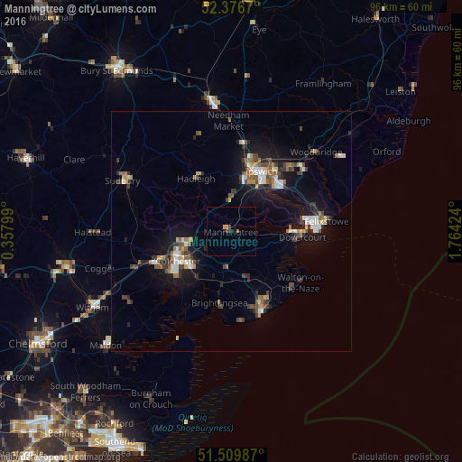
Analysis of Manningtree night lights 2016
Square area 10x10 km:
 0%
0%90-99
0%80-89
0%70-79
0.88%60-69
0.63%50-59
0%40-49
0%30-39
1.52%20-29
0%10-19
1.01%0-9
95.96%Square area 50x50 km:
0.76%90-99
0.85%80-89
0.51%70-79
0.63%60-69
0.9%50-59
0.9%40-49
1.03%30-39
1.11%20-29
1.34%10-19
5.55%0-9
86.43%Clear (daylight) street map image can be seen on geolist.org.
Map coordinates:
52° 22' 36.1" North, 0° 21' 28.8" East
51° 56' 43.4" North, 1° 3' 40" East
51° 30' 35.5" North, 1° 45' 51.3" East
Some cities around Manningtree sort by population:
• Ipswich
14.2 km =8.8 mi,  27°
27°
• Colchester
12.4 km =7.7 mi,  239°
239°
• Harwich
15.3 km =9.5 mi,  91°
91°
• Walton-on-the-Naze
17.8 km =11.1 mi,  127°
127°
• Kesgrave
17.7 km =11 mi,  42°
42°
• Wivenhoe
12.2 km =7.6 mi,  215°
215°
• Hadleigh
13.3 km =8.3 mi,  326°
326°
• Brightlingsea
15.1 km =9.4 mi,  189°
189°
2643107 (p: 5,696)
Sources (retrieved 2019-11-25):
» Earth at Night: Flat Maps 2012, 2016