Kearsley night lights from space
Night Light of Kearsley (England) from space (United Kingdom) Src. Average luminocity for 10x10km area is 76.8836% and for 50x50km: 50.1068%.
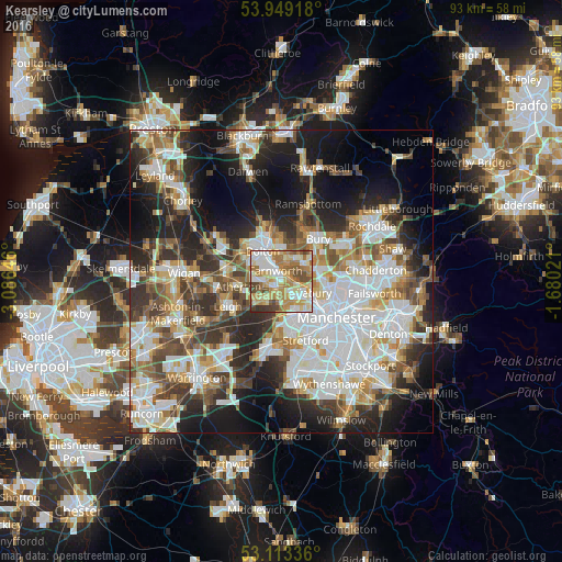
Analysis of Kearsley night lights 2016
Square area 10x10 km:
 14.15%
90-99
17.72%80-89
16.4%70-79
16.14%60-69
17.06%50-59
7.8%40-49
7.67%30-39
2.78%20-29
0.26%10-19
0%0-9
0%Square area 50x50 km:
13.16%90-99
11.48%80-89
5.04%70-79
5.25%60-69
6.32%50-59
5.87%40-49
6.6%30-39
6.53%20-29
10.47%10-19
14.73%0-9
14.55%Clear (daylight) street map image can be seen on geolist.org.
Map coordinates:
53° 56' 57" North, 3° 5' 11.3" West
53° 31' 60" North, 2° 22' 60" West
53° 6' 48.1" North, 1° 40' 48.8" West
Some cities around Kearsley sort by population:
• Walkden
2.2 km =1.4 mi,  210°
210°
• Tyldesley
6 km =3.7 mi,  248°
248°
• Radcliffe
5 km =3.1 mi,  50°
50°
• Farnworth
2.2 km =1.4 mi,  329°
329°
• Whitefield
5.8 km =3.6 mi,  71°
71°
• Swinton
4.3 km =2.7 mi,  149°
149°
• Little Lever
3.4 km =2.1 mi,  5°
5°
• Little Hulton
2.2 km =1.4 mi,  270°
270°
2645911 (p: 10,127)
Sources (retrieved 2019-11-25):
» Earth at Night: Flat Maps 2012, 2016