Jordanstown night lights from space
Night Light of Jordanstown (Northern Ireland) from space (United Kingdom) Src. Average luminocity for 10x10km area is 47.8484% and for 50x50km: 14.5046%.
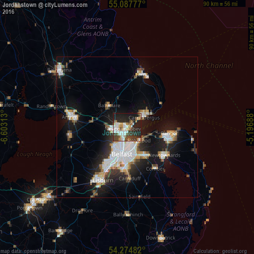
Analysis of Jordanstown night lights 2016
Square area 10x10 km:
 9.65%
9.65%90-99
10.65%80-89
3.76%70-79
5.26%60-69
4.26%50-59
5.76%40-49
7.14%30-39
10.78%20-29
17.79%10-19
24.94%0-9
0%Square area 50x50 km:
3.18%90-99
3.24%80-89
0.91%70-79
1.52%60-69
1.23%50-59
1.48%40-49
1.58%30-39
1.85%20-29
3.81%10-19
10.28%0-9
70.94%Clear (daylight) street map image can be seen on geolist.org.
Map coordinates:
55° 5' 16" North, 6° 36' 11.3" West
54° 40' 60" North, 5° 54' 0" West
54° 16' 29.4" North, 5° 11' 48.8" West
Some cities around Jordanstown sort by population:
• Belfast
9.8 km =6.1 mi,  189°
189°
• Newtownabbey
2.7 km =1.7 mi, 191°
• Castlereagh
12.3 km =7.6 mi,  175°
175°
• Carrickfergus
7 km =4.3 mi,  59°
59°
• Dundonald
12.1 km =7.5 mi,  147°
147°
• Holywood
6.9 km =4.3 mi,  135°
135°
• Ballyclare
9.9 km =6.2 mi,  319°
319°
• Greenisland
2.5 km =1.6 mi,  39°
39°
2645943 (p: 5,494)
Sources (retrieved 2019-11-25):
» Earth at Night: Flat Maps 2012, 2016