Ballyclare night lights from space
Night Light of Ballyclare (Northern Ireland) from space (United Kingdom) Src. Average luminocity for 10x10km area is 8.2381% and for 50x50km: 13.1275%.
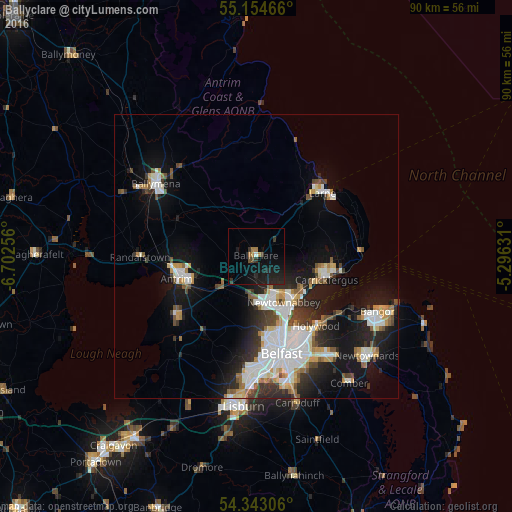
Analysis of Ballyclare night lights 2016
Square area 10x10 km:
 0.25%
0.25%90-99
0.25%80-89
0%70-79
0.5%60-69
2.01%50-59
0%40-49
1%30-39
2.26%20-29
4.39%10-19
15.41%0-9
73.93%Square area 50x50 km:
2.93%90-99
2.97%80-89
0.85%70-79
1.38%60-69
1.15%50-59
1.33%40-49
1.38%30-39
1.69%20-29
3.21%10-19
8.94%0-9
74.17%Clear (daylight) street map image can be seen on geolist.org.
Map coordinates:
55° 9' 16.8" North, 6° 42' 9.2" West
54° 45' 3.2" North, 5° 59' 58" West
54° 20' 35" North, 5° 17' 46.7" West
Some cities around Ballyclare sort by population:
• Belfast
17.8 km =11.1 mi,  164°
164°
• Newtownabbey
11.7 km =7.3 mi,  150°
150°
• Carrickfergus
13 km =8.1 mi,  107°
107°
• Antrim
14.1 km =8.8 mi,  246°
246°
• Larne
16.1 km =10 mi,  46°
46°
• Holywood
16.8 km =10.4 mi,  138°
138°
• Jordanstown
9.9 km =6.2 mi, 139°
• Greenisland
9.8 km =6.1 mi,  124°
124°
2656528 (p: 9,472)
Sources (retrieved 2019-11-25):
» Earth at Night: Flat Maps 2012, 2016