Timperley night lights from space
Night Light of Timperley (England) from space (United Kingdom) Src. Average luminocity for 10x10km area is 77.5966% and for 50x50km: 44.3109%.
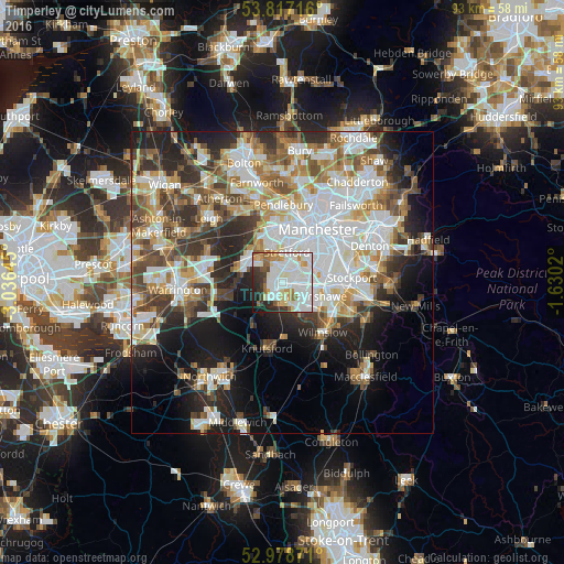
Analysis of Timperley night lights 2016
Square area 10x10 km:
 28.97%
90-99
28.84%80-89
5.29%70-79
5.95%60-69
4.89%50-59
4.63%40-49
2.78%30-39
6.75%20-29
7.94%10-19
3.97%0-9
0%Square area 50x50 km:
12%90-99
10.03%80-89
4.78%70-79
4.62%60-69
5.25%50-59
5.28%40-49
5.88%30-39
5.73%20-29
8.41%10-19
11.23%0-9
26.8%Clear (daylight) street map image can be seen on geolist.org.
Map coordinates:
53° 49' 1.8" North, 3° 2' 11.2" West
53° 24' 0" North, 2° 19' 60" West
52° 58' 43.4" North, 1° 37' 48.7" West
Some cities around Timperley sort by population:
• Sale
2.9 km =1.8 mi,  11°
11°
• Stretford
5.7 km =3.5 mi, 11°
• Altrincham
1.7 km =1.1 mi,  215°
215°
• Urmston
5.6 km =3.5 mi,  345°
345°
• Hale
2.4 km =1.5 mi,  179°
179°
• Didsbury
7 km =4.3 mi,  74°
74°
• Partington
6.6 km =4.1 mi,  288°
288°
• Bowdon
3.4 km =2.1 mi, 219°
2635803 (p: 11,049)
Sources (retrieved 2019-11-25):
» Earth at Night: Flat Maps 2012, 2016