Horsforth night lights from space
Night Light of Horsforth (England) from space (United Kingdom) Src. Average luminocity for 10x10km area is 78.4008% and for 50x50km: 35.3933%.
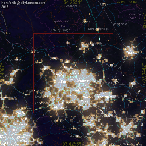
Analysis of Horsforth night lights 2016
Square area 10x10 km:
 27.91%
90-99
26.46%80-89
5.29%70-79
8.73%60-69
7.28%50-59
2.91%40-49
5.95%30-39
9.26%20-29
6.22%10-19
0%0-9
0%Square area 50x50 km:
9.44%90-99
8.27%80-89
3.04%70-79
3.6%60-69
4.4%50-59
4.41%40-49
3.94%30-39
4.92%20-29
7.01%10-19
9.08%0-9
41.88%Clear (daylight) street map image can be seen on geolist.org.
Map coordinates:
54° 15' 19.4" North, 2° 20' 26.4" West
53° 50' 33.4" North, 1° 38' 15.1" West
53° 25' 32.5" North, 0° 56' 3.9" West
Some cities around Horsforth sort by population:
• Leeds
7.8 km =4.8 mi,  131°
131°
• Yeadon
4.1 km =2.5 mi,  306°
306°
• Pudsey
5.5 km =3.4 mi,  196°
196°
• Shipley
8.5 km =5.3 mi,  263°
263°
• Guiseley
6.1 km =3.8 mi, 306°
• Chapel Allerton
6.7 km =4.2 mi,  103°
103°
• Otley
7.9 km =4.9 mi,  332°
332°
• Holbeck
8 km =5 mi,  145°
145°
2646558 (p: 19,350)
Sources (retrieved 2019-11-25):
» Earth at Night: Flat Maps 2012, 2016