Easington night lights from space
Night Light of Easington (England) from space (United Kingdom) Src. Average luminocity for 10x10km area is 29.4035% and for 50x50km: 28.1726%.
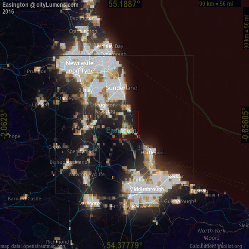
Analysis of Easington night lights 2016
Square area 10x10 km:
 3.13%
3.13%90-99
2.88%80-89
1.88%70-79
4.01%60-69
2.88%50-59
5.64%40-49
5.26%30-39
5.64%20-29
17.04%10-19
31.58%0-9
20.05%Square area 50x50 km:
8.57%90-99
6.43%80-89
2.24%70-79
2.4%60-69
2.65%50-59
2.43%40-49
2.39%30-39
3.88%20-29
6.42%10-19
13.06%0-9
49.53%Clear (daylight) street map image can be seen on geolist.org.
Map coordinates:
55° 11' 19.3" North, 2° 3' 44.3" West
54° 47' 7" North, 1° 21' 33" West
54° 22' 40" North, 0° 39' 21.8" West
Some cities around Easington sort by population:
• Sunderland
13.4 km =8.3 mi,  353°
353°
• Houghton-Le-Spring
9.1 km =5.7 mi,  312°
312°
• Peterlee
3.1 km =1.9 mi,  152°
152°
• Seaham
6 km =3.7 mi,  8°
8°
• Ryhope
9.6 km =6 mi,  355°
355°
• Hetton-Le-Hole
6.8 km =4.2 mi,  300°
300°
• Murton
4.2 km =2.6 mi,  331°
331°
• Wingate
6 km =3.7 mi,  192°
192°
2650518 (p: 7,193)
Sources (retrieved 2019-11-25):
» Earth at Night: Flat Maps 2012, 2016