Halstead night lights from space
Night Light of Halstead (England) from space (United Kingdom) Src. Average luminocity for 10x10km area is 1.2348% and for 50x50km: 4.6559%.
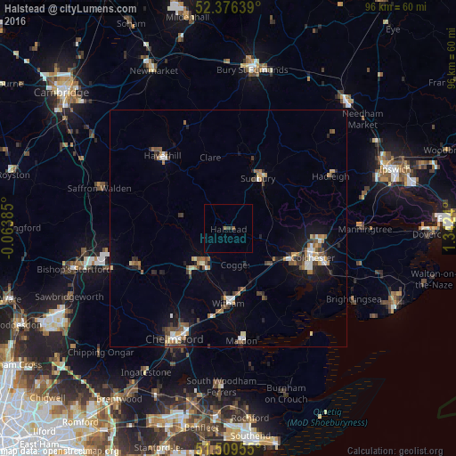
Analysis of Halstead night lights 2016
Square area 10x10 km:
 0%
0%90-99
0%80-89
0%70-79
0%60-69
0.38%50-59
0.63%40-49
0.13%30-39
0.88%20-29
0%10-19
0%0-9
97.98%Square area 50x50 km:
0.51%90-99
0.57%80-89
0.45%70-79
0.44%60-69
0.71%50-59
0.77%40-49
0.73%30-39
0.82%20-29
0.78%10-19
2.78%0-9
91.44%Clear (daylight) street map image can be seen on geolist.org.
Map coordinates:
52° 22' 35" North, 0° 3' 49.9" West
51° 56' 42.2" North, 0° 38' 21.4" East
51° 30' 34.4" North, 1° 20' 32.6" East
Some cities around Halstead sort by population:
• Colchester
19.2 km =11.9 mi,  108°
108°
• Braintree
9.5 km =5.9 mi,  218°
218°
• Haverhill
20.5 km =12.7 mi,  318°
318°
• Witham
16.1 km =10 mi,  179°
179°
• Sudbury
12.2 km =7.6 mi,  31°
31°
• Tiptree
16.5 km =10.3 mi,  153°
153°
• Great Dunmow
20.6 km =12.8 mi,  246°
246°
• Kelvedon
12.5 km =7.8 mi,  158°
158°
2647604 (p: 11,906)
Sources (retrieved 2019-11-25):
» Earth at Night: Flat Maps 2012, 2016