Wivenhoe night lights from space
Night Light of Wivenhoe (England) from space (United Kingdom) Src. Average luminocity for 10x10km area is 16.9962% and for 50x50km: 6.4192%.
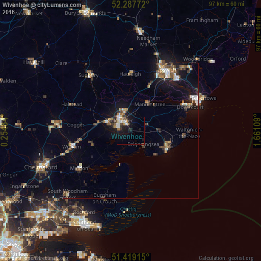
Analysis of Wivenhoe night lights 2016
Square area 10x10 km:
 3.66%
3.66%90-99
3.66%80-89
1.89%70-79
1.64%60-69
1.52%50-59
1.64%40-49
1.52%30-39
0.63%20-29
2.9%10-19
14.65%0-9
66.29%Square area 50x50 km:
0.82%90-99
0.83%80-89
0.52%70-79
0.6%60-69
0.95%50-59
0.96%40-49
1.06%30-39
1.31%20-29
1.14%10-19
4.67%0-9
87.15%Clear (daylight) street map image can be seen on geolist.org.
Map coordinates:
52° 17' 15.8" North, 0° 15' 17.4" East
51° 51' 19.9" North, 0° 57' 28.7" East
51° 25' 8.9" North, 1° 39' 39.9" East
Some cities around Wivenhoe sort by population:
• Colchester
5.3 km =3.3 mi,  315°
315°
• Clacton-on-Sea
15.5 km =9.6 mi,  118°
118°
• Frinton-on-Sea
19.9 km =12.4 mi,  98°
98°
• Tiptree
15.4 km =9.6 mi,  251°
251°
• Brightlingsea
6.6 km =4.1 mi,  137°
137°
• West Mersea
9 km =5.6 mi,  197°
197°
• Manningtree
12.2 km =7.6 mi,  35°
35°
• Kelvedon
17.4 km =10.8 mi,  264°
264°
2633717 (p: 9,567)
Sources (retrieved 2019-11-25):
» Earth at Night: Flat Maps 2012, 2016