Greenhill night lights from space
Night Light of Greenhill (England) from space (United Kingdom) Src. Average luminocity for 10x10km area is 93.5842% and for 50x50km: 62.1404%.
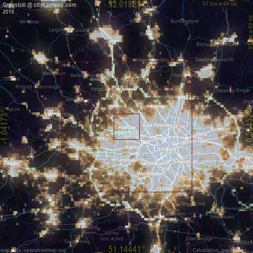
Analysis of Greenhill night lights 2016
Square area 10x10 km:
 42.38%
90-99
37.7%80-89
6.95%70-79
4.81%60-69
6.02%50-59
1.87%40-49
0.27%30-39
0%20-29
0%10-19
0%0-9
0%Square area 50x50 km:
24.51%90-99
13.95%80-89
5.59%70-79
4.42%60-69
6.09%50-59
6.52%40-49
6.27%30-39
6.4%20-29
7.54%10-19
9.54%0-9
9.17%Clear (daylight) street map image can be seen on geolist.org.
Map coordinates:
52° 1' 5.6" North, 1° 2' 30.2" West
51° 35' 0.3" North, 0° 20' 19" West
51° 8' 39.9" North, 0° 21' 52.3" East
Some cities around Greenhill sort by population:
• Brent
4.2 km =2.6 mi,  143°
143°
• Wembley
4.5 km =2.8 mi, 140°
• Ruislip
6 km =3.7 mi,  259°
259°
• Northolt
4.4 km =2.7 mi,  207°
207°
• Pinner
3.2 km =2 mi,  291°
291°
• Bushey
6.8 km =4.2 mi,  347°
347°
• Harrow on the Hill
1.4 km =0.9 mi,  165°
165°
• Edgware
5.5 km =3.4 mi,  53°
53°
6693776 (p: 9,324)
Sources (retrieved 2019-11-25):
» Earth at Night: Flat Maps 2012, 2016