Edgware night lights from space
Night Light of Edgware (England) from space (United Kingdom) Src. Average luminocity for 10x10km area is 87.7219% and for 50x50km: 62.8051%.
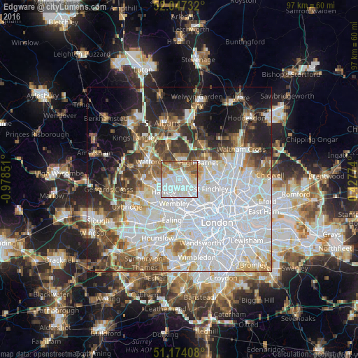
Analysis of Edgware night lights 2016
Square area 10x10 km:
 36.23%
90-99
28.61%80-89
5.48%70-79
7.22%60-69
14.3%50-59
7.75%40-49
0.4%30-39
0%20-29
0%10-19
0%0-9
0%Square area 50x50 km:
25.97%90-99
14.52%80-89
5.73%70-79
4.03%60-69
5.31%50-59
6.06%40-49
5.73%30-39
5.99%20-29
7.16%10-19
9.44%0-9
10.06%Clear (daylight) street map image can be seen on geolist.org.
Map coordinates:
52° 2' 50.4" North, 0° 58' 42.6" West
51° 36' 46.1" North, 0° 16' 31.4" West
51° 10' 26.7" North, 0° 25' 39.9" East
Some cities around Edgware sort by population:
• Brent
6.9 km =4.3 mi,  195°
195°
• Wembley
6.9 km =4.3 mi,  192°
192°
• Borehamwood
4.7 km =2.9 mi,  358°
358°
• Barnet
6.6 km =4.1 mi,  51°
51°
• Bushey
6.8 km =4.2 mi,  299°
299°
• Harrow on the Hill
6.1 km =3.8 mi,  221°
221°
• Greenhill
5.5 km =3.4 mi,  233°
233°
• High Barnet
6.7 km =4.2 mi,  44°
44°
2650228 (p: 9,832)
Sources (retrieved 2019-11-25):
» Earth at Night: Flat Maps 2012, 2016