Harrow on the Hill night lights from space
Night Light of Harrow on the Hill (England) from space (United Kingdom) Src. Average luminocity for 10x10km area is 96.0174% and for 50x50km: 62.9672%.
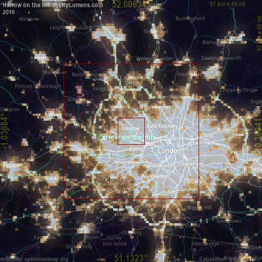
Analysis of Harrow on the Hill night lights 2016
Square area 10x10 km:
 47.19%
90-99
40.37%80-89
5.88%70-79
3.48%60-69
2.67%50-59
0.4%40-49
0%30-39
0%20-29
0%10-19
0%0-9
0%Square area 50x50 km:
24.78%90-99
14.14%80-89
5.74%70-79
4.61%60-69
6.17%50-59
6.6%40-49
6.32%30-39
6.51%20-29
7.65%10-19
9.1%0-9
8.38%Clear (daylight) street map image can be seen on geolist.org.
Map coordinates:
52° 0' 22.8" North, 1° 2' 12.6" West
51° 34' 17.1" North, 0° 20' 1.4" West
51° 7' 56.3" North, 0° 22' 9.9" East
Some cities around Harrow on the Hill sort by population:
• Brent
3 km =1.9 mi,  133°
133°
• Wembley
3.3 km =2.1 mi, 129°
• Greenford
5 km =3.1 mi,  197°
197°
• Ruislip
6.2 km =3.9 mi,  272°
272°
• Northolt
3.5 km =2.2 mi,  222°
222°
• Pinner
4.2 km =2.6 mi,  306°
306°
• Edgware
6.1 km =3.8 mi,  41°
41°
• Greenhill
1.4 km =0.9 mi,  345°
345°
2647421 (p: 10,632)
Sources (retrieved 2019-11-25):
» Earth at Night: Flat Maps 2012, 2016