Glyn-neath night lights from space
Night Light of Glyn-neath (Wales) from space (United Kingdom) Src. Average luminocity for 10x10km area is 1.0518% and for 50x50km: 9.6878%.
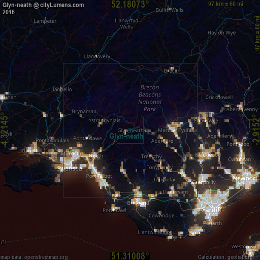
Analysis of Glyn-neath night lights 2016
Square area 10x10 km:
 0%
0%90-99
0%80-89
0%70-79
0.56%60-69
0%50-59
0.28%40-49
0.42%30-39
0.42%20-29
0%10-19
0%0-9
98.32%Square area 50x50 km:
0.99%90-99
1.37%80-89
0.71%70-79
1.33%60-69
1.23%50-59
1.2%40-49
1.29%30-39
1.57%20-29
3.28%10-19
10.22%0-9
76.8%Clear (daylight) street map image can be seen on geolist.org.
Map coordinates:
52° 10' 50.6" North, 4° 19' 17.2" West
51° 44' 51" North, 3° 37' 6" West
51° 18' 36.3" North, 2° 54' 54.7" West
Some cities around Glyn-neath sort by population:
• Rhondda
15.3 km =9.5 mi,  130°
130°
• Aberdare
12.2 km =7.6 mi,  107°
107°
• Maesteg
15.6 km =9.7 mi,  190°
190°
• Ystalyfera
11.4 km =7.1 mi,  281°
281°
• Treorchy
12.5 km =7.8 mi,  141°
141°
• Ferndale
15.2 km =9.4 mi, 129°
• Hirwaun
7.5 km =4.7 mi,  97°
97°
• Pentre
13.6 km =8.5 mi, 139°
2648385 (p: 5,419)
Sources (retrieved 2019-11-25):
» Earth at Night: Flat Maps 2012, 2016