Pentre night lights from space
Night Light of Pentre (Wales) from space (United Kingdom) Src. Average luminocity for 10x10km area is 6.5854% and for 50x50km: 16.1488%.
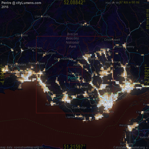
Analysis of Pentre night lights 2016
Square area 10x10 km:
 0%
0%90-99
0%80-89
0.56%70-79
0.28%60-69
1.82%50-59
1.82%40-49
1.12%30-39
2.24%20-29
1.96%10-19
1.4%0-9
88.8%Square area 50x50 km:
2.26%90-99
2.91%80-89
1.33%70-79
1.97%60-69
1.8%50-59
1.87%40-49
2.02%30-39
2.62%20-29
4.86%10-19
14.47%0-9
63.9%Clear (daylight) street map image can be seen on geolist.org.
Map coordinates:
52° 5' 18.3" North, 4° 11' 40.1" West
51° 39' 15.4" North, 3° 29' 28.8" West
51° 12' 57.5" North, 2° 47' 17.6" West
Some cities around Pentre sort by population:
• Tonypandy
4.4 km =2.7 mi,  145°
145°
• Rhondda
3 km =1.9 mi,  79°
79°
• Aberdare
7.3 km =4.5 mi,  23°
23°
• Mountain Ash
8.3 km =5.2 mi,  66°
66°
• Tonyrefail
8.9 km =5.5 mi, 151°
• Treorchy
1.2 km =0.7 mi,  300°
300°
• Ferndale
3.1 km =1.9 mi, 77°
• Hirwaun
9.5 km =5.9 mi,  352°
352°
8260056 (p: 5,424)
Sources (retrieved 2019-11-25):
» Earth at Night: Flat Maps 2012, 2016