Faversham night lights from space
Night Light of Faversham (England) from space (United Kingdom) Src. Average luminocity for 10x10km area is 6.902% and for 50x50km: 10.6976%.
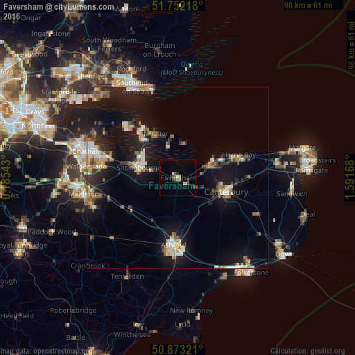
Analysis of Faversham night lights 2016
Square area 10x10 km:
 0.28%
0.28%90-99
0.7%80-89
0.42%70-79
0.84%60-69
2.1%50-59
0.14%40-49
2.66%30-39
0.7%20-29
2.1%10-19
0.14%0-9
89.92%Square area 50x50 km:
1.2%90-99
1.62%80-89
0.91%70-79
1.45%60-69
1.47%50-59
1.06%40-49
1.25%30-39
1.34%20-29
3.21%10-19
11.78%0-9
74.72%Clear (daylight) street map image can be seen on geolist.org.
Map coordinates:
51° 45' 7.8" North, 0° 11' 7.5" East
51° 18' 53.3" North, 0° 53' 18.8" East
50° 52' 23.6" North, 1° 35' 30" East
Some cities around Faversham sort by population:
• Ashford
18.7 km =11.6 mi,  183°
183°
• Canterbury
13.9 km =8.6 mi,  106°
106°
• Sittingbourne
11.2 km =7 mi,  285°
285°
• Herne Bay
17.9 km =11.1 mi,  68°
68°
• Whitstable
10.8 km =6.7 mi,  61°
61°
• Sheerness
16.5 km =10.3 mi,  327°
327°
• Sturry
16.3 km =10.1 mi,  95°
95°
• Rainham
20.2 km =12.6 mi, 285°
2649622 (p: 19,829)
Sources (retrieved 2019-11-25):
» Earth at Night: Flat Maps 2012, 2016