Epping night lights from space
Night Light of Epping (England) from space (United Kingdom) Src. Average luminocity for 10x10km area is 27.3109% and for 50x50km: 41.5322%.
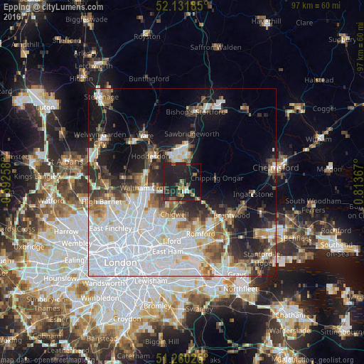
Analysis of Epping night lights 2016
Square area 10x10 km:
 0.7%
0.7%90-99
1.96%80-89
1.54%70-79
4.34%60-69
3.36%50-59
3.64%40-49
3.5%30-39
3.92%20-29
25.07%10-19
43%0-9
8.96%Square area 50x50 km:
16.46%90-99
8.39%80-89
3.64%70-79
2.72%60-69
3.51%50-59
4%40-49
3.92%30-39
3.88%20-29
7.14%10-19
12.82%0-9
33.53%Clear (daylight) street map image can be seen on geolist.org.
Map coordinates:
52° 7' 54.7" North, 0° 35' 33.3" West
51° 41' 53.3" North, 0° 6' 38" East
51° 15' 36.9" North, 0° 48' 49.2" East
Some cities around Epping sort by population:
• Harlow
8.7 km =5.4 mi,  0°
0°
• Cheshunt
9.7 km =6 mi,  271°
271°
• Waltham Abbey
8 km =5 mi,  261°
261°
• Grange Hill
9.7 km =6 mi,  189°
189°
• Buckhurst Hill
9.8 km =6.1 mi,  213°
213°
• Chigwell
9 km =5.6 mi,  195°
195°
• Old Harlow
9.6 km =6 mi,  9°
9°
• Chipping Ongar
9.3 km =5.8 mi,  86°
86°
2649963 (p: 10,289)
Sources (retrieved 2019-11-25):
» Earth at Night: Flat Maps 2012, 2016