Chipping Ongar night lights from space
Night Light of Chipping Ongar (England) from space (United Kingdom) Src. Average luminocity for 10x10km area is 3.7563% and for 50x50km: 34.3477%.
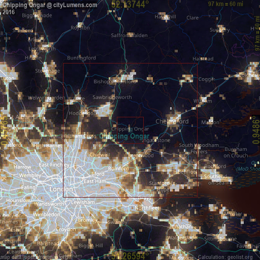
Analysis of Chipping Ongar night lights 2016
Square area 10x10 km:
 0%
0%90-99
0%80-89
0.14%70-79
0%60-69
0%50-59
0.7%40-49
0.7%30-39
0.42%20-29
0.42%10-19
5.18%0-9
92.44%Square area 50x50 km:
11.59%90-99
6.64%80-89
2.99%70-79
2.58%60-69
3.3%50-59
3.74%40-49
4.14%30-39
4.19%20-29
7.01%10-19
12.46%0-9
41.36%Clear (daylight) street map image can be seen on geolist.org.
Map coordinates:
52° 8' 14.8" North, 0° 27' 27.5" West
51° 42' 13.6" North, 0° 14' 43.7" East
51° 15' 57.4" North, 0° 56' 55" East
Some cities around Chipping Ongar sort by population:
• Harlow
12.3 km =7.6 mi,  311°
311°
• Brentwood
10.1 km =6.3 mi,  155°
155°
• Harold Wood
12.2 km =7.6 mi,  184°
184°
• Epping
9.3 km =5.8 mi,  266°
266°
• Collier Row
12.9 km =8 mi,  205°
205°
• Sawbridgeworth
14.2 km =8.8 mi,  332°
332°
• Old Harlow
11.7 km =7.3 mi,  319°
319°
• Ingatestone
10.2 km =6.3 mi,  111°
111°
2653138 (p: 6,093)
Sources (retrieved 2019-11-25):
» Earth at Night: Flat Maps 2012, 2016