Chigwell night lights from space
Night Light of Chigwell (England) from space (United Kingdom) Src. Average luminocity for 10x10km area is 69.9225% and for 50x50km: 55.6647%.
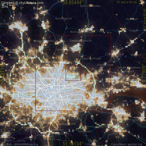
Analysis of Chigwell night lights 2016
Square area 10x10 km:
 16.44%
90-99
21.26%80-89
7.62%70-79
7.22%60-69
8.56%50-59
11.36%40-49
9.76%30-39
9.09%20-29
7.62%10-19
1.07%0-9
0%Square area 50x50 km:
24.33%90-99
12.57%80-89
5.16%70-79
3.68%60-69
4.02%50-59
4.26%40-49
3.77%30-39
4.34%20-29
8.04%10-19
10.07%0-9
19.76%Clear (daylight) street map image can be seen on geolist.org.
Map coordinates:
52° 3' 16" North, 0° 37' 37.8" West
51° 37' 12" North, 0° 4' 33.5" East
51° 10' 52.8" North, 0° 46' 44.7" East
Some cities around Chigwell sort by population:
• Becontree
8.3 km =5.2 mi,  153°
153°
• Woodford Green
3.8 km =2.4 mi,  252°
252°
• Grange Hill
1.1 km =0.7 mi,  142°
142°
• Buckhurst Hill
3 km =1.9 mi,  278°
278°
• Epping
9 km =5.6 mi,  15°
15°
• Collier Row
6.6 km =4.1 mi,  110°
110°
• Chadwell Heath
6.7 km =4.2 mi, 144°
• Hainault
2.5 km =1.6 mi,  120°
120°
2653178 (p: 10,354)
Sources (retrieved 2019-11-25):
» Earth at Night: Flat Maps 2012, 2016