Grange Hill night lights from space
Night Light of Grange Hill (England) from space (United Kingdom) Src. Average luminocity for 10x10km area is 71.8422% and for 50x50km: 55.9186%.
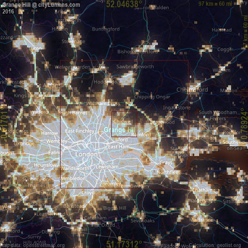
Analysis of Grange Hill night lights 2016
Square area 10x10 km:
 18.72%
90-99
22.06%80-89
7.49%70-79
8.29%60-69
8.29%50-59
10.43%40-49
8.69%30-39
7.49%20-29
7.22%10-19
1.34%0-9
0%Square area 50x50 km:
24.18%90-99
12.56%80-89
5.39%70-79
3.79%60-69
4.02%50-59
4.22%40-49
3.8%30-39
4.36%20-29
8.35%10-19
10.69%0-9
18.63%Clear (daylight) street map image can be seen on geolist.org.
Map coordinates:
52° 2' 47" North, 0° 37' 1.2" West
51° 36' 42.7" North, 0° 5' 10" East
51° 10' 23.2" North, 0° 47' 21.3" East
Some cities around Grange Hill sort by population:
• Becontree
7.2 km =4.5 mi,  155°
155°
• Romford
8 km =5 mi,  120°
120°
• Woodford Green
4.3 km =2.7 mi,  266°
266°
• Buckhurst Hill
3.9 km =2.4 mi,  290°
290°
• Chigwell
1.1 km =0.7 mi,  322°
322°
• Collier Row
5.7 km =3.5 mi,  104°
104°
• Chadwell Heath
5.5 km =3.4 mi,  144°
144°
• Hainault
1.5 km =0.9 mi, 104°
6690801 (p: 12,449)
Sources (retrieved 2019-11-25):
» Earth at Night: Flat Maps 2012, 2016