Edenbridge night lights from space
Night Light of Edenbridge (England) from space (United Kingdom) Src. Average luminocity for 10x10km area is 2.3155% and for 50x50km: 19.9343%.
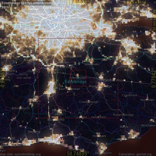
Analysis of Edenbridge night lights 2016
Square area 10x10 km:
 0%
0%90-99
0%80-89
0%70-79
0.53%60-69
0.8%50-59
0.8%40-49
0.4%30-39
0.27%20-29
0.4%10-19
0.27%0-9
96.52%Square area 50x50 km:
3.21%90-99
3.48%80-89
2.21%70-79
2.44%60-69
3.01%50-59
2.7%40-49
3.35%30-39
2.97%20-29
5.14%10-19
9.78%0-9
61.71%Clear (daylight) street map image can be seen on geolist.org.
Map coordinates:
51° 37' 49" North, 0° 38' 9" West
51° 11' 30.2" North, 0° 4' 2.2" East
50° 44' 56.2" North, 0° 46' 13.5" East
Some cities around Edenbridge sort by population:
• Royal Tunbridge Wells
15.1 km =9.4 mi,  115°
115°
• Tonbridge
14.4 km =8.9 mi,  88°
88°
• Sevenoaks
12.4 km =7.7 mi,  43°
43°
• East Grinstead
9.1 km =5.7 mi,  214°
214°
• Caterham
14.3 km =8.9 mi,  314°
314°
• Biggin Hill
13.7 km =8.5 mi,  350°
350°
• Oxted
8.9 km =5.5 mi,  324°
324°
• Warlingham
15.7 km =9.8 mi,  326°
326°
2650246 (p: 8,172)
Sources (retrieved 2019-11-25):
» Earth at Night: Flat Maps 2012, 2016