Warlingham night lights from space
Night Light of Warlingham (England) from space (United Kingdom) Src. Average luminocity for 10x10km area is 40.5812% and for 50x50km: 45.2632%.
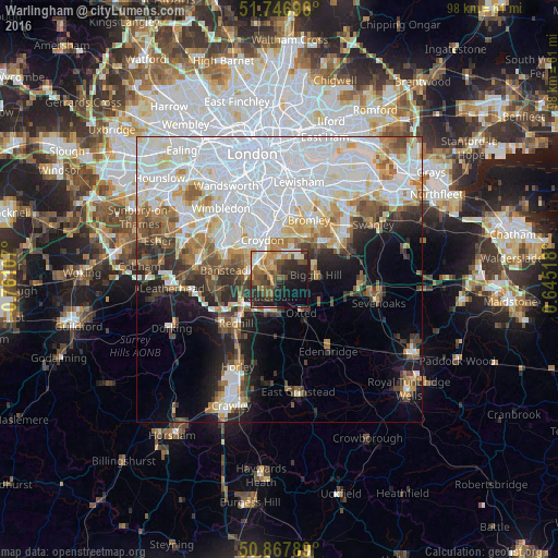
Analysis of Warlingham night lights 2016
Square area 10x10 km:
 3.5%
3.5%90-99
3.92%80-89
3.92%70-79
7.98%60-69
8.12%50-59
8.12%40-49
10.64%30-39
7.28%20-29
15.27%10-19
19.89%0-9
11.34%Square area 50x50 km:
17.88%90-99
10.35%80-89
3.99%70-79
3.83%60-69
4.33%50-59
3.9%40-49
3.89%30-39
3.65%20-29
5.21%10-19
8.07%0-9
34.91%Clear (daylight) street map image can be seen on geolist.org.
Map coordinates:
51° 44' 49.1" North, 0° 45' 39.9" West
51° 18' 34.3" North, 0° 3' 28.6" West
50° 52' 4.4" North, 0° 38' 42.6" East
Some cities around Warlingham sort by population:
• Croydon
8.7 km =5.4 mi,  340°
340°
• Purley
4.8 km =3 mi,  308°
308°
• South Croydon
6.4 km =4 mi, 336°
• Coulsdon
5.9 km =3.7 mi,  281°
281°
• Caterham
3.4 km =2.1 mi,  205°
205°
• West Wickham
7 km =4.3 mi,  24°
24°
• Biggin Hill
6.4 km =4 mi,  86°
86°
• Oxted
6.9 km =4.3 mi,  148°
148°
2634759 (p: 7,970)
Sources (retrieved 2019-11-25):
» Earth at Night: Flat Maps 2012, 2016