Diss night lights from space
Night Light of Diss (England) from space (United Kingdom) Src. Average luminocity for 10x10km area is 2.6919% and for 50x50km: 1.716%.
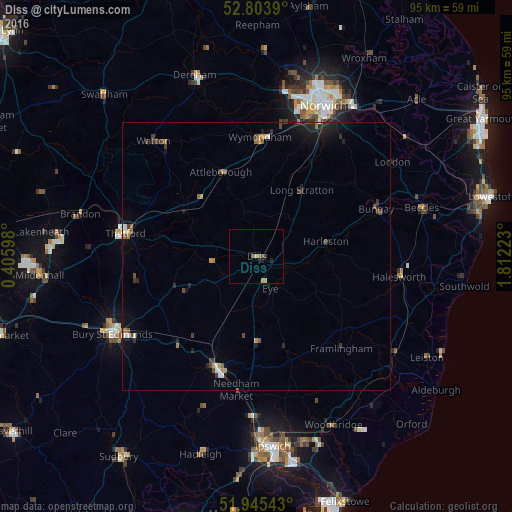
Analysis of Diss night lights 2016
Square area 10x10 km:
 0%
0%90-99
0%80-89
0.51%70-79
1.01%60-69
0.51%50-59
0.13%40-49
0.88%30-39
0.51%20-29
0.51%10-19
1.01%0-9
94.95%Square area 50x50 km:
0.09%90-99
0.19%80-89
0.05%70-79
0.23%60-69
0.24%50-59
0.24%40-49
0.38%30-39
0.4%20-29
0.47%10-19
1.24%0-9
96.46%Clear (daylight) street map image can be seen on geolist.org.
Map coordinates:
52° 48' 14" North, 0° 24' 21.5" East
52° 22' 36.3" North, 1° 6' 32.8" East
51° 56' 43.5" North, 1° 48' 44" East
Some cities around Diss sort by population:
• Thetford
24.8 km =15.4 mi,  280°
280°
• Stowmarket
22.2 km =13.8 mi,  199°
199°
• Attleborough
16.9 km =10.5 mi,  338°
338°
• Watton
28.2 km =17.5 mi,  318°
318°
• Halesworth
27 km =16.8 mi,  97°
97°
• Hethersett
24.9 km =15.5 mi,  10°
10°
• Poringland
26.7 km =16.6 mi,  37°
37°
• Bungay
23.9 km =14.9 mi,  68°
68°
2651214 (p: 10,734)
Sources (retrieved 2019-11-25):
» Earth at Night: Flat Maps 2012, 2016