Watton night lights from space
Night Light of Watton (England) from space (United Kingdom) Src. Average luminocity for 10x10km area is 1.996% and for 50x50km: 2.3647%.
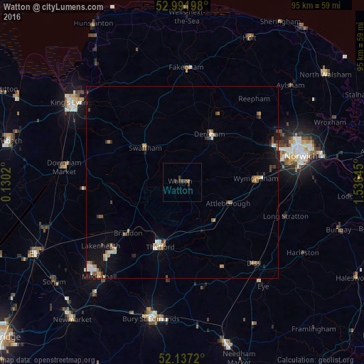
Analysis of Watton night lights 2016
Square area 10x10 km:
 0%
0%90-99
0%80-89
0%70-79
0%60-69
0.53%50-59
0%40-49
1.46%30-39
2.25%20-29
0%10-19
0.53%0-9
95.24%Square area 50x50 km:
0.26%90-99
0.33%80-89
0.13%70-79
0.38%60-69
0.37%50-59
0.31%40-49
0.41%30-39
0.41%20-29
0.25%10-19
1.41%0-9
95.74%Clear (daylight) street map image can be seen on geolist.org.
Map coordinates:
52° 59' 31.1" North, 0° 7' 48.7" East
52° 34' 0" North, 0° 49' 60" East
52° 8' 13.9" North, 1° 32' 11.2" East
Some cities around Watton sort by population:
• Thetford
17.6 km =10.9 mi,  198°
198°
• East Dereham
14.6 km =9.1 mi,  27°
27°
• Bowthorpe
27.2 km =16.9 mi,  72°
72°
• Diss
28.2 km =17.5 mi,  138°
138°
• Attleborough
13.5 km =8.4 mi,  113°
113°
• Fakenham
29.3 km =18.2 mi,  1°
1°
• Swaffham
13.4 km =8.3 mi,  312°
312°
• Hethersett
23.2 km =14.4 mi,  81°
81°
2634662 (p: 9,924)
Sources (retrieved 2019-11-25):
» Earth at Night: Flat Maps 2012, 2016