Poringland night lights from space
Night Light of Poringland (England) from space (United Kingdom) Src. Average luminocity for 10x10km area is 6.3929% and for 50x50km: 4.7379%.
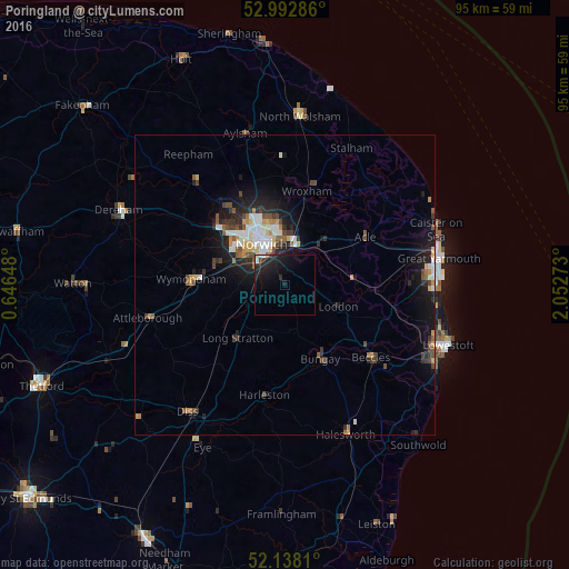
Analysis of Poringland night lights 2016
Square area 10x10 km:
 0.79%
0.79%90-99
0.26%80-89
0.26%70-79
0%60-69
0.26%50-59
0.53%40-49
0.53%30-39
0.79%20-29
5.16%10-19
13.1%0-9
78.31%Square area 50x50 km:
0.7%90-99
0.81%80-89
0.4%70-79
0.54%60-69
0.36%50-59
0.59%40-49
0.88%30-39
0.68%20-29
1.41%10-19
3.94%0-9
89.69%Clear (daylight) street map image can be seen on geolist.org.
Map coordinates:
52° 59' 34.3" North, 0° 38' 47.3" East
52° 34' 3.2" North, 1° 20' 58.6" East
52° 8' 17.2" North, 2° 3' 9.8" East
Some cities around Poringland sort by population:
• Norwich
7.5 km =4.7 mi,  332°
332°
• Bowthorpe
11.9 km =7.4 mi,  311°
311°
• Beccles
18.9 km =11.7 mi,  129°
129°
• Attleborough
23.2 km =14.4 mi,  256°
256°
• Thorpe Hamlet
7.2 km =4.5 mi,  339°
339°
• Brundall
8.5 km =5.3 mi,  42°
42°
• Hethersett
12.4 km =7.7 mi,  285°
285°
• Bungay
13.9 km =8.6 mi,  154°
154°
2640090 (p: 5,132)
Sources (retrieved 2019-11-25):
» Earth at Night: Flat Maps 2012, 2016