Attleborough night lights from space
Night Light of Attleborough (England) from space (United Kingdom) Src. Average luminocity for 10x10km area is 1.5833% and for 50x50km: 4.4348%.
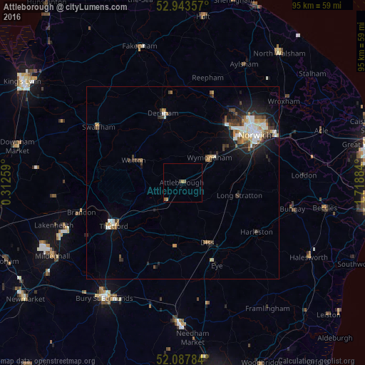
Analysis of Attleborough night lights 2016
Square area 10x10 km:
 0%
0%90-99
0%80-89
0%70-79
0.53%60-69
0.53%50-59
1.06%40-49
0%30-39
0.53%20-29
0%10-19
0%0-9
97.35%Square area 50x50 km:
0.72%90-99
0.81%80-89
0.39%70-79
0.5%60-69
0.41%50-59
0.52%40-49
0.71%30-39
0.62%20-29
1.28%10-19
2.84%0-9
91.18%Clear (daylight) street map image can be seen on geolist.org.
Map coordinates:
52° 56' 36.9" North, 0° 18' 45.3" East
52° 31' 4" North, 1° 0' 56.6" East
52° 5' 16.2" North, 1° 43' 7.8" East
Some cities around Attleborough sort by population:
• Norwich
22.7 km =14.1 mi,  57°
57°
• Thetford
21.2 km =13.2 mi,  238°
238°
• East Dereham
19.2 km =11.9 mi,  343°
343°
• Bowthorpe
19.2 km =11.9 mi,  45°
45°
• Diss
16.9 km =10.5 mi,  158°
158°
• Watton
13.5 km =8.4 mi,  293°
293°
• Hethersett
13.9 km =8.6 mi, 50°
• Poringland
23.2 km =14.4 mi,  76°
76°
2656836 (p: 10,549)
Sources (retrieved 2019-11-25):
» Earth at Night: Flat Maps 2012, 2016