Kiveton Park night lights from space
Night Light of Kiveton Park (England) from space (United Kingdom) Src. Average luminocity for 10x10km area is 22.6679% and for 50x50km: 26.9234%.
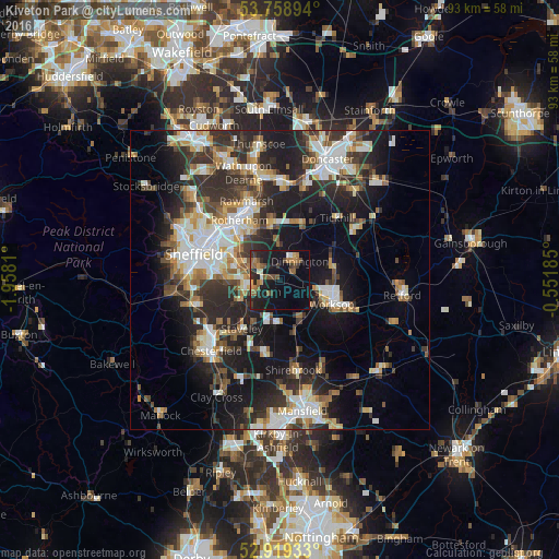
Analysis of Kiveton Park night lights 2016
Square area 10x10 km:
 0.38%
0.38%90-99
1.52%80-89
1.14%70-79
2.65%60-69
4.67%50-59
6.57%40-49
2.65%30-39
3.41%20-29
9.6%10-19
29.04%0-9
38.38%Square area 50x50 km:
4.48%90-99
5.33%80-89
2.77%70-79
2.93%60-69
2.94%50-59
3.36%40-49
3.54%30-39
5.22%20-29
9.38%10-19
15.68%0-9
44.37%Clear (daylight) street map image can be seen on geolist.org.
Map coordinates:
53° 45' 32.2" North, 1° 57' 29.2" West
53° 20' 28.3" North, 1° 15' 17.9" West
52° 55' 9.6" North, 0° 33' 6.7" West
Some cities around Kiveton Park sort by population:
• Worksop
9.7 km =6 mi,  116°
116°
• Dinnington
4.6 km =2.9 mi,  52°
52°
• Maltby
9.1 km =5.7 mi,  23°
23°
• Beighton
5.3 km =3.3 mi,  260°
260°
• Killamarsh
4.5 km =2.8 mi,  244°
244°
• Clowne
7.4 km =4.6 mi,  184°
184°
• Wales
1.8 km =1.1 mi,  267°
267°
• Creswell
9 km =5.6 mi,  165°
165°
2645174 (p: 8,703)
Sources (retrieved 2019-11-25):
» Earth at Night: Flat Maps 2012, 2016