Chepstow night lights from space
Night Light of Chepstow (Wales) from space (United Kingdom) Src. Average luminocity for 10x10km area is 9.2815% and for 50x50km: 14.0503%.
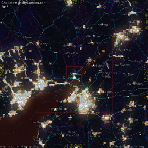
Analysis of Chepstow night lights 2016
Square area 10x10 km:
 0.84%
0.84%90-99
1.4%80-89
0%70-79
1.68%60-69
0.98%50-59
2.52%40-49
0.42%30-39
1.12%20-29
1.54%10-19
2.38%0-9
87.11%Square area 50x50 km:
2.64%90-99
3.02%80-89
1.35%70-79
1.57%60-69
1.5%50-59
1.85%40-49
1.61%30-39
1.76%20-29
3.73%10-19
7.05%0-9
73.92%Clear (daylight) street map image can be seen on geolist.org.
Map coordinates:
52° 4' 30.4" North, 3° 22' 47.9" West
51° 38' 27.1" North, 2° 40' 36.6" West
51° 12' 8.7" North, 1° 58' 25.4" West
Some cities around Chepstow sort by population:
• Portishead
18.8 km =11.7 mi,  199°
199°
• Stoke Gifford
16.7 km =10.4 mi,  145°
145°
• Thornbury
11.4 km =7.1 mi,  108°
108°
• Caldicot
8.2 km =5.1 mi,  222°
222°
• Coleford
17.7 km =11 mi,  14°
14°
• Lydney
14.1 km =8.8 mi,  47°
47°
• Magor
12.7 km =7.9 mi,  237°
237°
• Undy
12 km =7.5 mi,  232°
232°
2653256 (p: 16,169)
Sources (retrieved 2019-11-25):
» Earth at Night: Flat Maps 2012, 2016