Sawbridgeworth night lights from space
Night Light of Sawbridgeworth (England) from space (United Kingdom) Src. Average luminocity for 10x10km area is 19.2913% and for 50x50km: 19.8005%.
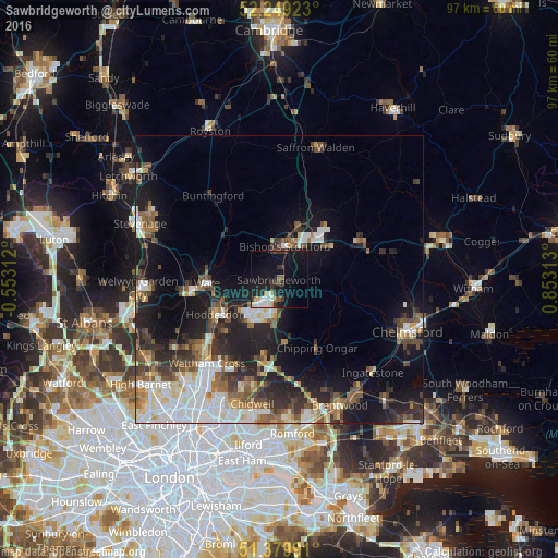
Analysis of Sawbridgeworth night lights 2016
Square area 10x10 km:
 2.24%
2.24%90-99
3.78%80-89
1.26%70-79
1.54%60-69
0.7%50-59
1.54%40-49
1.26%30-39
5.32%20-29
4.9%10-19
31.93%0-9
45.52%Square area 50x50 km:
3.81%90-99
4.02%80-89
1.83%70-79
1.46%60-69
2.31%50-59
2.91%40-49
3.22%30-39
3.11%20-29
5.28%10-19
12.15%0-9
59.9%Clear (daylight) street map image can be seen on geolist.org.
Map coordinates:
52° 14' 57.2" North, 0° 33' 11.2" West
51° 49' 0" North, 0° 9' 0" East
51° 22' 47.7" North, 0° 51' 11.3" East
Some cities around Sawbridgeworth sort by population:
• Harlow
5.2 km =3.2 mi,  210°
210°
• Bishops Stortford
6.1 km =3.8 mi,  5°
5°
• Hoddesdon
12.7 km =7.9 mi,  241°
241°
• Ware
12.3 km =7.6 mi,  266°
266°
• Broxbourne
14 km =8.7 mi, 236°
• Epping
13.5 km =8.4 mi,  191°
191°
• Old Harlow
3.8 km =2.4 mi,  196°
196°
• Stansted Mountfitchet
9.9 km =6.2 mi,  20°
20°
2638481 (p: 8,400)
Sources (retrieved 2019-11-25):
» Earth at Night: Flat Maps 2012, 2016