Collier Row night lights from space
Night Light of Collier Row (England) from space (United Kingdom) Src. Average luminocity for 10x10km area is 68.9693% and for 50x50km: 53.0603%.
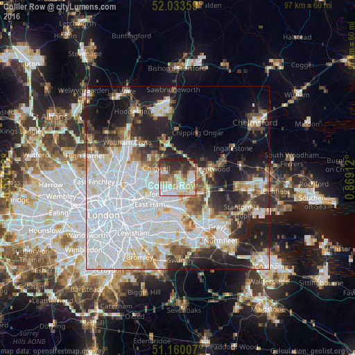
Analysis of Collier Row night lights 2016
Square area 10x10 km:
 17.78%
90-99
16.44%80-89
13.24%70-79
8.29%60-69
7.62%50-59
7.35%40-49
5.35%30-39
10.43%20-29
12.7%10-19
0.8%0-9
0%Square area 50x50 km:
21.55%90-99
11.83%80-89
5.25%70-79
3.82%60-69
3.98%50-59
4.2%40-49
4.12%30-39
4.36%20-29
8.67%10-19
13.38%0-9
18.83%Clear (daylight) street map image can be seen on geolist.org.
Map coordinates:
52° 2' 0.9" North, 0° 32' 13.7" West
51° 35' 56.1" North, 0° 9' 57.6" East
51° 9' 36.3" North, 0° 52' 8.8" East
Some cities around Collier Row sort by population:
• Dagenham
5.4 km =3.4 mi,  179°
179°
• Becontree
5.7 km =3.5 mi,  206°
206°
• Romford
3 km =1.9 mi,  152°
152°
• Hornchurch
5.8 km =3.6 mi,  143°
143°
• Grange Hill
5.7 km =3.5 mi,  284°
284°
• Harold Wood
4.6 km =2.9 mi,  95°
95°
• Chadwell Heath
3.8 km =2.4 mi,  216°
216°
• Hainault
4.2 km =2.6 mi, 284°
6690802 (p: 10,100)
Sources (retrieved 2019-11-25):
» Earth at Night: Flat Maps 2012, 2016