Stoke Gifford night lights from space
Night Light of Stoke Gifford (England) from space (United Kingdom) Src. Average luminocity for 10x10km area is 58.8864% and for 50x50km: 12.6553%.
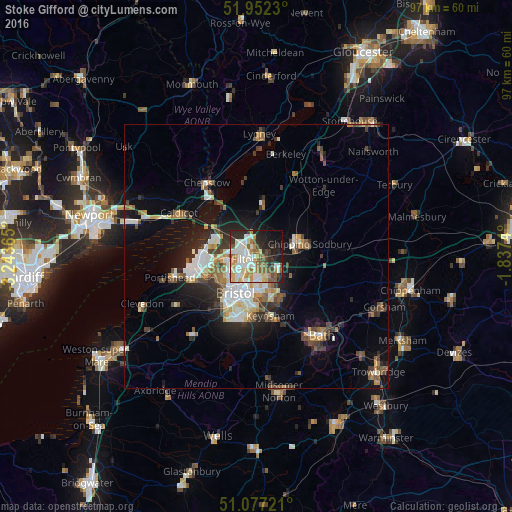
Analysis of Stoke Gifford night lights 2016
Square area 10x10 km:
 13.64%
90-99
14.44%80-89
8.56%70-79
8.29%60-69
6.28%50-59
8.42%40-49
4.55%30-39
5.48%20-29
14.04%10-19
11.9%0-9
4.41%Square area 50x50 km:
2.03%90-99
2.42%80-89
1.13%70-79
1.33%60-69
1.44%50-59
1.98%40-49
1.66%30-39
1.78%20-29
3.27%10-19
6.73%0-9
76.23%Clear (daylight) street map image can be seen on geolist.org.
Map coordinates:
51° 57' 8.3" North, 3° 14' 37.1" West
51° 31' 0.7" North, 2° 32' 25.9" West
51° 4' 38" North, 1° 50' 14.6" West
Some cities around Stoke Gifford sort by population:
• Bristol
7.9 km =4.9 mi,  209°
209°
• Kingswood
7.5 km =4.7 mi,  162°
162°
• Mangotsfield
4.1 km =2.5 mi,  141°
141°
• Chipping Sodbury
10.4 km =6.5 mi,  76°
76°
• Yate
8.9 km =5.5 mi,  72°
72°
• Keynsham
11.8 km =7.3 mi,  165°
165°
• Thornbury
10.3 km =6.4 mi,  7°
7°
• Bishopsworth
12.6 km =7.8 mi, 206°
2636854 (p: 13,560)
Sources (retrieved 2019-11-25):
» Earth at Night: Flat Maps 2012, 2016