Chelmsley Wood night lights from space
Night Light of Chelmsley Wood (England) from space (United Kingdom) Src. Average luminocity for 10x10km area is 79.4722% and for 50x50km: 42.7721%.
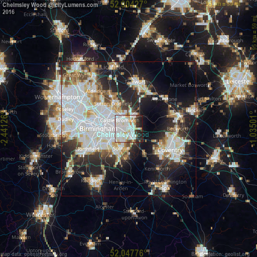
Analysis of Chelmsley Wood night lights 2016
Square area 10x10 km:
 35.23%
90-99
28.91%80-89
3.91%70-79
4.8%60-69
4.17%50-59
1.64%40-49
2.4%30-39
4.29%20-29
9.97%10-19
4.67%0-9
0%Square area 50x50 km:
13.12%90-99
11.3%80-89
3.76%70-79
3.6%60-69
3.8%50-59
3.29%40-49
3.64%30-39
4.11%20-29
9.65%10-19
17.16%0-9
26.54%Clear (daylight) street map image can be seen on geolist.org.
Map coordinates:
52° 54' 15.4" North, 2° 26' 28.5" West
52° 28' 41.2" North, 1° 44' 17.3" West
52° 2' 51.9" North, 1° 2' 6" West
Some cities around Chelmsley Wood sort by population:
• Birmingham
11 km =6.8 mi,  271°
271°
• Solihull
7.7 km =4.8 mi,  202°
202°
• Washwood Heath
6.5 km =4 mi,  292°
292°
• Aston
10.1 km =6.3 mi,  283°
283°
• Shirley
9.3 km =5.8 mi,  216°
216°
• Acocks Green
6.2 km =3.9 mi,  239°
239°
• Knowle
10.5 km =6.5 mi,  178°
178°
• Castle Vale
6 km =3.7 mi,  318°
318°
6698373 (p: 13,010)
Sources (retrieved 2019-11-25):
» Earth at Night: Flat Maps 2012, 2016