Knowle night lights from space
Night Light of Knowle (England) from space (United Kingdom) Src. Average luminocity for 10x10km area is 37.072% and for 50x50km: 36.7721%.
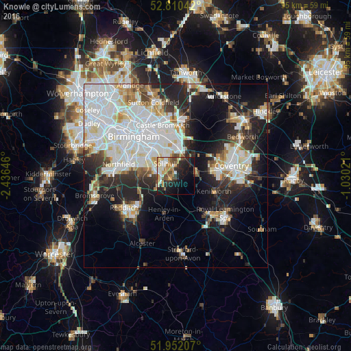
Analysis of Knowle night lights 2016
Square area 10x10 km:
 5.18%
5.18%90-99
6.57%80-89
3.91%70-79
8.59%60-69
5.18%50-59
3.79%40-49
5.68%30-39
3.54%20-29
10.73%10-19
22.35%0-9
24.49%Square area 50x50 km:
12.09%90-99
9.99%80-89
3.1%70-79
2.75%60-69
2.86%50-59
2.47%40-49
2.73%30-39
3.54%20-29
8.28%10-19
13.38%0-9
38.82%Clear (daylight) street map image can be seen on geolist.org.
Map coordinates:
52° 48' 37.5" North, 2° 26' 11.3" West
52° 22' 60" North, 1° 43' 60" West
51° 57' 7.5" North, 1° 1' 48.8" West
Some cities around Knowle sort by population:
• Solihull
4.7 km =2.9 mi,  316°
316°
• Washwood Heath
14.5 km =9 mi,  334°
334°
• Shirley
6.6 km =4.1 mi,  297°
297°
• Acocks Green
9.3 km =5.8 mi, 322°
• Kenilworth
10.9 km =6.8 mi,  110°
110°
• Chelmsley Wood
10.5 km =6.5 mi,  358°
358°
• Dorridge
1.8 km =1.1 mi,  228°
228°
• Balsall Common
5.7 km =3.5 mi,  80°
80°
2645099 (p: 10,823)
Sources (retrieved 2019-11-25):
» Earth at Night: Flat Maps 2012, 2016