Garforth night lights from space
Night Light of Garforth (England) from space (United Kingdom) Src. Average luminocity for 10x10km area is 42.123% and for 50x50km: 34.4321%.
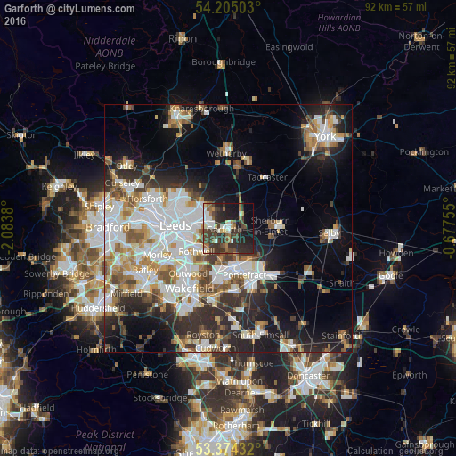
Analysis of Garforth night lights 2016
Square area 10x10 km:
 5.95%
5.95%90-99
7.94%80-89
2.51%70-79
2.38%60-69
6.48%50-59
4.63%40-49
11.11%30-39
16.67%20-29
17.72%10-19
17.59%0-9
7.01%Square area 50x50 km:
8.97%90-99
7.9%80-89
2.67%70-79
3.53%60-69
4.01%50-59
3.81%40-49
3.76%30-39
4.97%20-29
8.29%10-19
11.42%0-9
40.7%Clear (daylight) street map image can be seen on geolist.org.
Map coordinates:
54° 12' 18.1" North, 2° 5' 1.7" West
53° 47' 30.2" North, 1° 22' 50.4" West
53° 22' 27.6" North, 0° 40' 39.2" West
Some cities around Garforth sort by population:
• Leeds
11 km =6.8 mi,  272°
272°
• Castleford
7.4 km =4.6 mi,  170°
170°
• Pontefract
12.1 km =7.5 mi,  158°
158°
• Lofthouse
10.3 km =6.4 mi,  227°
227°
• Chapel Allerton
11.2 km =7 mi,  291°
291°
• Kippax
2.8 km =1.7 mi, 167°
• Sherburn in Elmet
8.8 km =5.5 mi,  87°
87°
• Holbeck
12.3 km =7.6 mi, 265°
2648875 (p: 14,838)
Sources (retrieved 2019-11-25):
» Earth at Night: Flat Maps 2012, 2016