Bromborough night lights from space
Night Light of Bromborough (England) from space (United Kingdom) Src. Average luminocity for 10x10km area is 66.4392% and for 50x50km: 34.2335%.
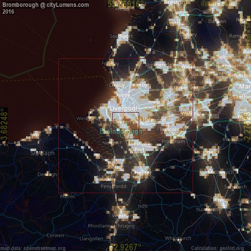
Analysis of Bromborough night lights 2016
Square area 10x10 km:
 17.99%
90-99
17.59%80-89
9.26%70-79
3.97%60-69
6.35%50-59
4.5%40-49
14.95%30-39
12.83%20-29
9.52%10-19
3.04%0-9
0%Square area 50x50 km:
9.22%90-99
8.01%80-89
3.07%70-79
2.86%60-69
3.29%50-59
3.31%40-49
4.93%30-39
6.3%20-29
9.02%10-19
10.13%0-9
39.85%Clear (daylight) street map image can be seen on geolist.org.
Map coordinates:
53° 45' 58.2" North, 3° 40' 56.9" West
53° 20' 54.6" North, 2° 58' 45.7" West
52° 55' 36.1" North, 2° 16' 34.4" West
Some cities around Bromborough sort by population:
• Liverpool
6.9 km =4.3 mi,  0°
0°
• Birkenhead
5.5 km =3.4 mi,  334°
334°
• Ellesmere Port
9.3 km =5.8 mi,  146°
146°
• Heswall
8.1 km =5 mi,  253°
253°
• Bebington
2.5 km =1.6 mi,  273°
273°
• Neston
8.6 km =5.3 mi,  212°
212°
• Prenton
5.4 km =3.4 mi,  293°
293°
• New Ferry
1.6 km =1 mi,  324°
324°
2654596 (p: 14,850)
Sources (retrieved 2019-11-25):
» Earth at Night: Flat Maps 2012, 2016