New Ferry night lights from space
Night Light of New Ferry (England) from space (United Kingdom) Src. Average luminocity for 10x10km area is 72.7447% and for 50x50km: 33.9866%.
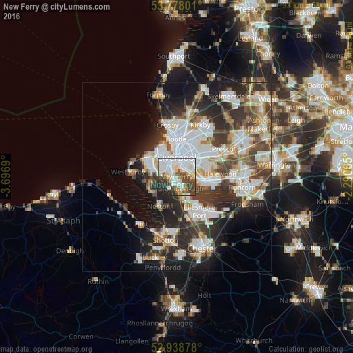
Analysis of New Ferry night lights 2016
Square area 10x10 km:
 25.4%
25.4%90-99
21.16%80-89
8.99%70-79
2.78%60-69
4.5%50-59
4.5%40-49
13.1%30-39
10.32%20-29
8.33%10-19
0.93%0-9
0%Square area 50x50 km:
9.11%90-99
7.94%80-89
3.07%70-79
2.79%60-69
3.29%50-59
3.28%40-49
4.84%30-39
6.29%20-29
9.19%10-19
10.46%0-9
39.75%Clear (daylight) street map image can be seen on geolist.org.
Map coordinates:
53° 46' 40.8" North, 3° 41' 48.8" West
53° 21' 37.7" North, 2° 59' 37.6" West
52° 56' 19.6" North, 2° 17' 26.3" West
Some cities around New Ferry sort by population:
• Liverpool
5.7 km =3.5 mi,  10°
10°
• Birkenhead
3.9 km =2.4 mi,  339°
339°
• Wallasey
8.4 km =5.2 mi,  325°
325°
• Heswall
7.7 km =4.8 mi,  241°
241°
• Bebington
1.9 km =1.2 mi,  232°
232°
• Bromborough
1.6 km =1 mi,  144°
144°
• Prenton
4.1 km =2.5 mi,  281°
281°
• Greasby
8.7 km =5.4 mi, 279°
2641649 (p: 5,300)
Sources (retrieved 2019-11-25):
» Earth at Night: Flat Maps 2012, 2016