Prenton night lights from space
Night Light of Prenton (England) from space (United Kingdom) Src. Average luminocity for 10x10km area is 69.7341% and for 50x50km: 30.8768%.
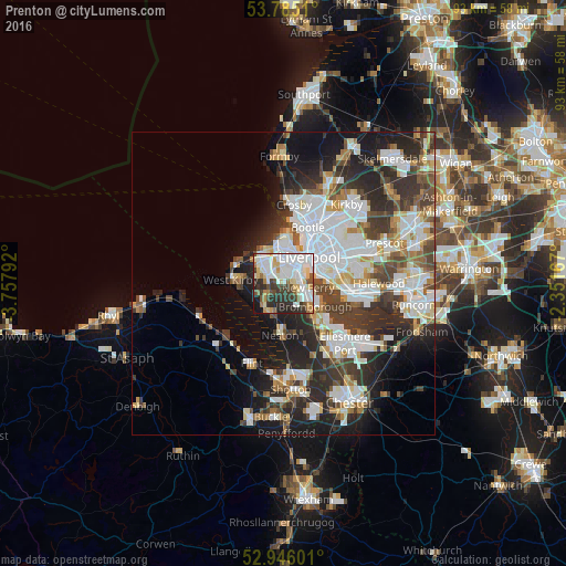
Analysis of Prenton night lights 2016
Square area 10x10 km:
 22.62%
90-99
21.83%80-89
8.33%70-79
4.5%60-69
4.76%50-59
4.1%40-49
5.95%30-39
11.11%20-29
12.96%10-19
3.7%0-9
0.13%Square area 50x50 km:
8.57%90-99
7.18%80-89
2.53%70-79
2.38%60-69
2.86%50-59
2.95%40-49
4.15%30-39
5.79%20-29
8.75%10-19
10.04%0-9
44.8%Clear (daylight) street map image can be seen on geolist.org.
Map coordinates:
53° 47' 6.4" North, 3° 45' 28.5" West
53° 22' 3.4" North, 3° 3' 17.2" West
52° 56' 45.6" North, 2° 21' 6" West
Some cities around Prenton sort by population:
• Birkenhead
3.9 km =2.4 mi,  42°
42°
• Wallasey
6.2 km =3.9 mi,  353°
353°
• Heswall
5.3 km =3.3 mi,  211°
211°
• Moreton
5.5 km =3.4 mi,  311°
311°
• Bebington
3.2 km =2 mi,  127°
127°
• Bromborough
5.4 km =3.4 mi,  113°
113°
• Greasby
4.6 km =2.9 mi,  277°
277°
• New Ferry
4.1 km =2.5 mi,  101°
101°
6694080 (p: 14,429)
Sources (retrieved 2019-11-25):
» Earth at Night: Flat Maps 2012, 2016