Brixton Hill night lights from space
Night Light of Brixton Hill (England) from space (United Kingdom) Src. Average luminocity for 10x10km area is 99.8104% and for 50x50km: 67.9213%.
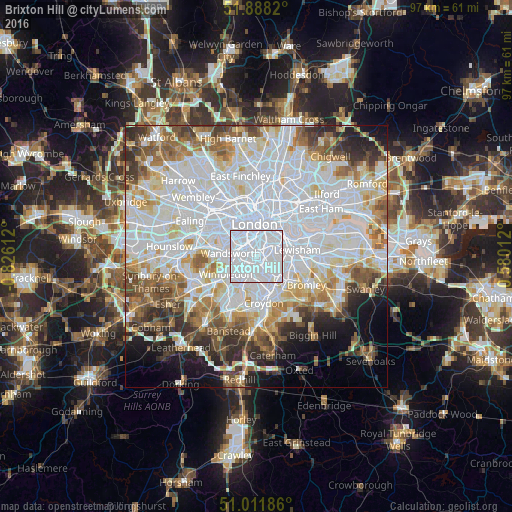
Analysis of Brixton Hill night lights 2016
Square area 10x10 km:
 89.22%
90-99
10.78%80-89
0%70-79
0%60-69
0%50-59
0%40-49
0%30-39
0%20-29
0%10-19
0%0-9
0%Square area 50x50 km:
28.74%90-99
16.88%80-89
6.33%70-79
5.38%60-69
6.12%50-59
6.06%40-49
4.75%30-39
4.55%20-29
5.21%10-19
5.67%0-9
10.31%Clear (daylight) street map image can be seen on geolist.org.
Map coordinates:
51° 53' 17.5" North, 0° 49' 34" West
51° 27' 7.7" North, 0° 7' 22.8" West
51° 0' 42.7" North, 0° 34' 48.4" East
Some cities around Brixton Hill sort by population:
• City of Westminster
5.1 km =3.2 mi,  350°
350°
• Battersea
3.4 km =2.1 mi,  318°
318°
• Peckham
4.4 km =2.7 mi,  56°
56°
• Chelsea
5.1 km =3.2 mi, 320°
• Mitcham
6.3 km =3.9 mi,  210°
210°
• Earlsfield
4.4 km =2.7 mi,  258°
258°
• Thornton Heath
6.2 km =3.9 mi,  164°
164°
• Lambeth
5 km =3.1 mi,  9°
9°
6692466 (p: 12,458)
Sources (retrieved 2019-11-25):
» Earth at Night: Flat Maps 2012, 2016