Earlsfield night lights from space
Night Light of Earlsfield (England) from space (United Kingdom) Src. Average luminocity for 10x10km area is 97.3714% and for 50x50km: 67.3145%.
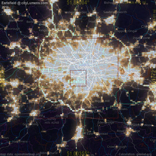
Analysis of Earlsfield night lights 2016
Square area 10x10 km:
 72.34%
90-99
17.4%80-89
5.45%70-79
2.99%60-69
1.56%50-59
0.26%40-49
0%30-39
0%20-29
0%10-19
0%0-9
0%Square area 50x50 km:
28.44%90-99
16.43%80-89
5.96%70-79
5.19%60-69
6.28%50-59
6.17%40-49
5.28%30-39
4.99%20-29
5.25%10-19
6.05%0-9
9.96%Clear (daylight) street map image can be seen on geolist.org.
Map coordinates:
51° 52' 48.1" North, 0° 53' 18.7" West
51° 26' 38" North, 0° 11' 7.4" West
51° 0' 12.8" North, 0° 31' 3.8" East
Some cities around Earlsfield sort by population:
• City of Westminster
6.9 km =4.3 mi,  30°
30°
• Battersea
4 km =2.5 mi, 31°
• Brixton
6 km =3.7 mi,  65°
65°
• Chelsea
5 km =3.1 mi,  12°
12°
• Mitcham
4.7 km =2.9 mi,  165°
165°
• Morden
5.2 km =3.2 mi,  190°
190°
• New Malden
7.1 km =4.4 mi,  227°
227°
• Brixton Hill
4.4 km =2.7 mi,  78°
78°
8063096 (p: 15,562)
Sources (retrieved 2019-11-25):
» Earth at Night: Flat Maps 2012, 2016