Brentford night lights from space
Night Light of Brentford (England) from space (United Kingdom) Src. Average luminocity for 10x10km area is 94.3463% and for 50x50km: 65.6612%.
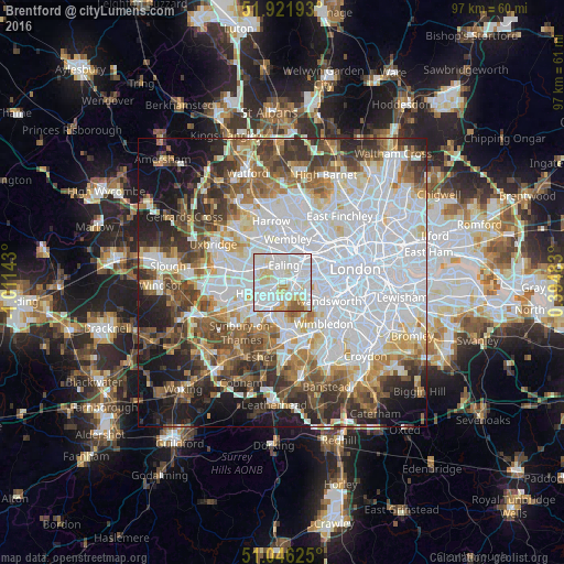
Analysis of Brentford night lights 2016
Square area 10x10 km:
 44.92%
90-99
34.76%80-89
11.76%70-79
4.01%60-69
0.94%50-59
3.61%40-49
0%30-39
0%20-29
0%10-19
0%0-9
0%Square area 50x50 km:
25.6%90-99
14.7%80-89
5.93%70-79
5.21%60-69
6.52%50-59
7.07%40-49
6.86%30-39
6.9%20-29
7.45%10-19
9.13%0-9
4.63%Clear (daylight) street map image can be seen on geolist.org.
Map coordinates:
51° 55' 18.9" North, 1° 0' 41.1" West
51° 29' 10.3" North, 0° 18' 29.9" West
51° 2' 46.5" North, 0° 23' 41.4" East
Some cities around Brentford sort by population:
• Wembley
7.4 km =4.6 mi,  6°
6°
• Southall
5 km =3.1 mi,  300°
300°
• Hounslow
4.1 km =2.5 mi,  241°
241°
• Acton
3.4 km =2.1 mi,  41°
41°
• Greenford
5.7 km =3.5 mi,  325°
325°
• Isleworth
2.7 km =1.7 mi, 242°
• Teddington
7.3 km =4.5 mi,  192°
192°
• Richmond
2.7 km =1.7 mi,  177°
177°
2654787 (p: 10,750)
Sources (retrieved 2019-11-25):
» Earth at Night: Flat Maps 2012, 2016