Teddington night lights from space
Night Light of Teddington (England) from space (United Kingdom) Src. Average luminocity for 10x10km area is 80.6364% and for 50x50km: 59.9359%.
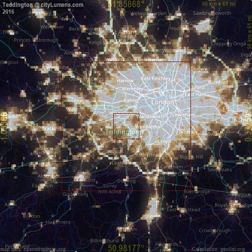
Analysis of Teddington night lights 2016
Square area 10x10 km:
 21.93%
90-99
27.54%80-89
6.82%70-79
10.56%60-69
13.24%50-59
10.56%40-49
7.35%30-39
2.01%20-29
0%10-19
0%0-9
0%Square area 50x50 km:
24.12%90-99
13.26%80-89
4.95%70-79
4.63%60-69
5.72%50-59
6.08%40-49
6.02%30-39
5.53%20-29
6.81%10-19
11.48%0-9
11.4%Clear (daylight) street map image can be seen on geolist.org.
Map coordinates:
51° 51' 31.2" North, 1° 2' 1.2" West
51° 25' 20.4" North, 0° 19' 49.9" West
50° 58' 54.4" North, 0° 22' 21.3" East
Some cities around Teddington sort by population:
• Surbiton
4.1 km =2.5 mi,  146°
146°
• New Malden
5.3 km =3.3 mi,  116°
116°
• West Molesey
4.2 km =2.6 mi,  233°
233°
• East Molesey
2.9 km =1.8 mi,  206°
206°
• Hampton
2.7 km =1.7 mi,  248°
248°
• Kingston upon Thames
2.5 km =1.6 mi, 115°
• Richmond
4.7 km =2.9 mi,  20°
20°
• Thames Ditton
3.7 km =2.3 mi,  189°
189°
2636147 (p: 9,615)
Sources (retrieved 2019-11-25):
» Earth at Night: Flat Maps 2012, 2016