Bourne night lights from space
Night Light of Bourne (England) from space (United Kingdom) Src. Average luminocity for 10x10km area is 5.9545% and for 50x50km: 6.1644%.
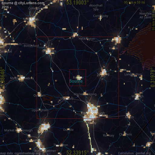
Analysis of Bourne night lights 2016
Square area 10x10 km:
 0.38%
0.38%90-99
0.63%80-89
1.77%70-79
1.14%60-69
0.13%50-59
1.39%40-49
1.01%30-39
0.13%20-29
0%10-19
0.51%0-9
92.93%Square area 50x50 km:
0.94%90-99
1.06%80-89
0.55%70-79
0.69%60-69
0.9%50-59
0.84%40-49
0.83%30-39
0.75%20-29
1.48%10-19
3.06%0-9
88.88%Clear (daylight) street map image can be seen on geolist.org.
Map coordinates:
53° 11' 24.1" North, 1° 5' 11.3" West
52° 46' 0" North, 0° 22' 60" West
52° 20' 20.9" North, 0° 19' 11.2" East
Some cities around Bourne sort by population:
• Peterborough
23.3 km =14.5 mi,  156°
156°
• Grantham
23.7 km =14.7 mi,  312°
312°
• Spalding
15.8 km =9.8 mi,  81°
81°
• Stamford
14.6 km =9.1 mi,  207°
207°
• Sleaford
25.8 km =16 mi,  356°
356°
• Market Deeping
11 km =6.8 mi, 155°
• Oakham
26.1 km =16.2 mi,  244°
244°
• Great Gonerby
26.7 km =16.6 mi, 314°
2655099 (p: 13,961)
Sources (retrieved 2019-11-25):
» Earth at Night: Flat Maps 2012, 2016