Great Gonerby night lights from space
Night Light of Great Gonerby (England) from space (United Kingdom) Src. Average luminocity for 10x10km area is 16.9048% and for 50x50km: 4.4148%.
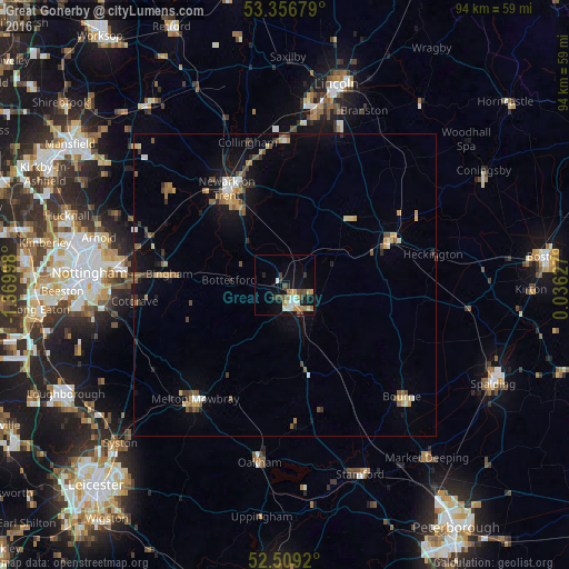
Analysis of Great Gonerby night lights 2016
Square area 10x10 km:
 1.32%
1.32%90-99
3.97%80-89
0.66%70-79
3.31%60-69
2.91%50-59
1.46%40-49
3.57%30-39
2.51%20-29
1.98%10-19
10.05%0-9
68.25%Square area 50x50 km:
0.33%90-99
0.47%80-89
0.46%70-79
0.7%60-69
0.53%50-59
0.86%40-49
0.79%30-39
0.51%20-29
0.57%10-19
2.76%0-9
92.02%Clear (daylight) street map image can be seen on geolist.org.
Map coordinates:
53° 21' 24.4" North, 1° 22' 11.9" West
52° 56' 6.3" North, 0° 40' 0.7" West
52° 30' 33.1" North, 0° 2' 10.6" East
Some cities around Great Gonerby sort by population:
• Grantham
3.1 km =1.9 mi,  147°
147°
• Newark on Trent
17.7 km =11 mi,  325°
325°
• Melton Mowbray
23.9 km =14.9 mi,  218°
218°
• Sleaford
18.6 km =11.6 mi,  67°
67°
• Bingham
19.6 km =12.2 mi,  274°
274°
• Radcliffe on Trent
24.9 km =15.5 mi, 273°
• Cotgrave
25 km =15.5 mi,  263°
263°
• Ruskington
22.4 km =13.9 mi,  56°
56°
2648096 (p: 5,853)
Sources (retrieved 2019-11-25):
» Earth at Night: Flat Maps 2012, 2016