Blacon night lights from space
Night Light of Blacon (England) from space (United Kingdom) Src. Average luminocity for 10x10km area is 53.8447% and for 50x50km: 26.3234%.
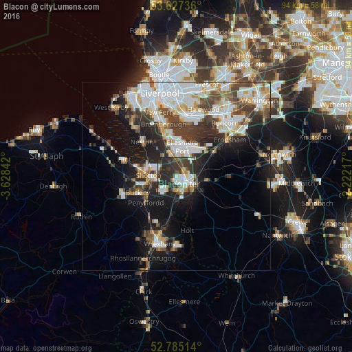
Analysis of Blacon night lights 2016
Square area 10x10 km:
 11.74%
90-99
11.74%80-89
5.43%70-79
2.65%60-69
7.07%50-59
3.54%40-49
7.83%30-39
20.08%20-29
28.79%10-19
1.14%0-9
0%Square area 50x50 km:
6.76%90-99
6.09%80-89
2.34%70-79
2.04%60-69
2.59%50-59
2.52%40-49
3.76%30-39
4.35%20-29
6.59%10-19
11.04%0-9
51.92%Clear (daylight) street map image can be seen on geolist.org.
Map coordinates:
53° 37' 38.5" North, 3° 37' 42.3" West
53° 12' 30" North, 2° 55' 31.1" West
52° 47' 6.5" North, 2° 13' 19.8" West
Some cities around Blacon sort by population:
• Chester
3 km =1.9 mi,  131°
131°
• Ellesmere Port
8 km =5 mi,  11°
11°
• Buckley
11.5 km =7.1 mi,  246°
246°
• Deeside
7.6 km =4.7 mi,  263°
263°
• Hawarden
7.2 km =4.5 mi, 248°
• Neston
11.8 km =7.3 mi,  315°
315°
• Broughton
6.8 km =4.2 mi,  221°
221°
• Helsby
12.7 km =7.9 mi,  54°
54°
6698331 (p: 13,495)
Sources (retrieved 2019-11-25):
» Earth at Night: Flat Maps 2012, 2016