Benson night lights from space
Night Light of Benson (England) from space (United Kingdom) Src. Average luminocity for 10x10km area is 5.9479% and for 50x50km: 14.6236%.
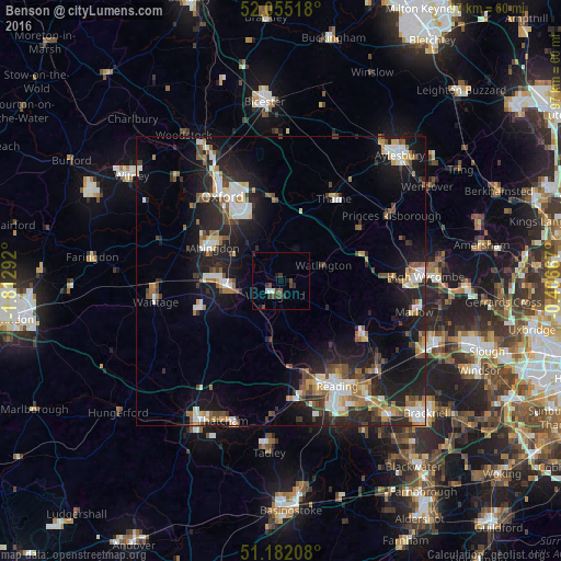
Analysis of Benson night lights 2016
Square area 10x10 km:
 0%
0%90-99
1.6%80-89
0%70-79
0%60-69
0%50-59
0.53%40-49
3.74%30-39
2.01%20-29
1.87%10-19
1.47%0-9
88.77%Square area 50x50 km:
2.07%90-99
2.67%80-89
1.17%70-79
1.57%60-69
1.91%50-59
1.71%40-49
2.35%30-39
1.72%20-29
5.25%10-19
11.37%0-9
68.22%Clear (daylight) street map image can be seen on geolist.org.
Map coordinates:
52° 3' 18.6" North, 1° 48' 46.5" West
51° 37' 14.6" North, 1° 6' 35.2" West
51° 10' 55.5" North, 0° 24' 24" West
Some cities around Benson sort by population:
• Abingdon
13.2 km =8.2 mi,  295°
295°
• Didcot
9.2 km =5.7 mi,  262°
262°
• Cowley
14.1 km =8.8 mi,  331°
331°
• Thame
16.9 km =10.5 mi,  32°
32°
• Wallingford
2.5 km =1.6 mi,  204°
204°
• Wheatley
14.2 km =8.8 mi,  351°
351°
• Chinnor
16.4 km =10.2 mi,  56°
56°
• West Ilsley
17.3 km =10.7 mi,  238°
238°
2655886 (p: 5,802)
Sources (retrieved 2019-11-25):
» Earth at Night: Flat Maps 2012, 2016