Chinnor night lights from space
Night Light of Chinnor (England) from space (United Kingdom) Src. Average luminocity for 10x10km area is 4.3557% and for 50x50km: 13.8337%.
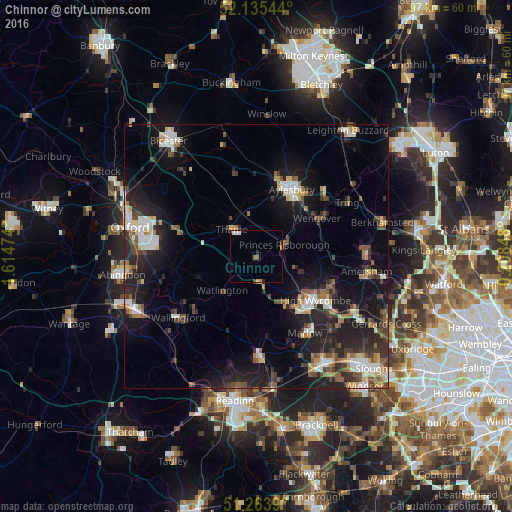
Analysis of Chinnor night lights 2016
Square area 10x10 km:
 0.98%
0.98%90-99
0.7%80-89
0.28%70-79
0.56%60-69
0%50-59
1.12%40-49
0.28%30-39
0.28%20-29
0.84%10-19
0.28%0-9
94.68%Square area 50x50 km:
1.73%90-99
2.2%80-89
1.25%70-79
1.31%60-69
1.55%50-59
1.79%40-49
2.48%30-39
2.05%20-29
5.36%10-19
11.53%0-9
68.75%Clear (daylight) street map image can be seen on geolist.org.
Map coordinates:
52° 8' 7.6" North, 1° 36' 53.1" West
51° 42' 6.4" North, 0° 54' 41.8" West
51° 15' 50" North, 0° 12' 30.5" West
Some cities around Chinnor sort by population:
• High Wycombe
13.8 km =8.6 mi,  125°
125°
• Aylesbury
14.4 km =8.9 mi,  27°
27°
• Thame
6.8 km =4.2 mi,  319°
319°
• Princes Risborough
6.1 km =3.8 mi,  64°
64°
• Wendover
13.6 km =8.5 mi, 60°
• Great Missenden
14 km =8.7 mi,  88°
88°
• Benson
16.4 km =10.2 mi,  236°
236°
• Wheatley
16.5 km =10.3 mi,  287°
287°
2653145 (p: 5,473)
Sources (retrieved 2019-11-25):
» Earth at Night: Flat Maps 2012, 2016