Belvedere night lights from space
Night Light of Belvedere (England) from space (United Kingdom) Src. Average luminocity for 10x10km area is 92.0628% and for 50x50km: 57.2001%.
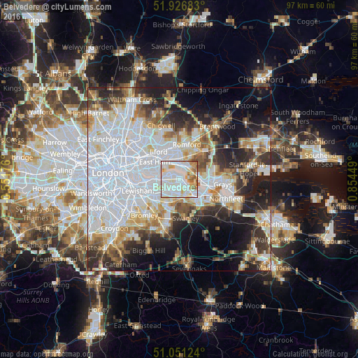
Analysis of Belvedere night lights 2016
Square area 10x10 km:
 37.17%
90-99
37.17%80-89
8.16%70-79
9.09%60-69
3.61%50-59
4.28%40-49
0.53%30-39
0%20-29
0%10-19
0%0-9
0%Square area 50x50 km:
22.42%90-99
12.56%80-89
5.62%70-79
4.83%60-69
5.03%50-59
4.71%40-49
4.89%30-39
5.43%20-29
8.97%10-19
11.22%0-9
14.33%Clear (daylight) street map image can be seen on geolist.org.
Map coordinates:
51° 55' 36.6" North, 0° 33' 6.3" West
51° 29' 28.1" North, 0° 9' 4.9" East
51° 3' 4.5" North, 0° 51' 16.2" East
Some cities around Belvedere sort by population:
• Bexley
5.5 km =3.4 mi,  181°
181°
• Dagenham
6.6 km =4.1 mi,  9°
9°
• Barking
6.6 km =4.1 mi,  314°
314°
• Dartford
6.6 km =4.1 mi,  138°
138°
• Welling
4.4 km =2.7 mi,  223°
223°
• Abbey Wood
3.1 km =1.9 mi,  261°
261°
• Purfleet
6.4 km =4 mi,  97°
97°
• Erith
1.9 km =1.2 mi,  118°
118°
2655929 (p: 11,000)
Sources (retrieved 2019-11-25):
» Earth at Night: Flat Maps 2012, 2016