Purfleet night lights from space
Night Light of Purfleet (England) from space (United Kingdom) Src. Average luminocity for 10x10km area is 84.5989% and for 50x50km: 51.7307%.
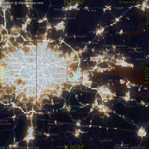
Analysis of Purfleet night lights 2016
Square area 10x10 km:
 27.81%
90-99
28.34%80-89
7.89%70-79
10.43%60-69
13.5%50-59
8.02%40-49
3.34%30-39
0.67%20-29
0%10-19
0%0-9
0%Square area 50x50 km:
17.51%90-99
11.17%80-89
5.24%70-79
4.85%60-69
5.23%50-59
4.85%40-49
5.1%30-39
6.12%20-29
9.59%10-19
13.51%0-9
16.82%Clear (daylight) street map image can be seen on geolist.org.
Map coordinates:
51° 55' 10.8" North, 0° 27' 38.4" West
51° 29' 2" North, 0° 14' 32.9" East
51° 2' 38.2" North, 0° 56' 44.1" East
Some cities around Purfleet sort by population:
• Grays
5.8 km =3.6 mi,  99°
99°
• Dartford
4.6 km =2.9 mi,  205°
205°
• South Ockendon
3.9 km =2.4 mi,  46°
46°
• Chafford Hundred
3.6 km =2.2 mi,  80°
80°
• Erith
4.7 km =2.9 mi,  268°
268°
• Aveley
1.9 km =1.2 mi,  19°
19°
• West Thurrock
2.5 km =1.6 mi, 104°
• Stone
4 km =2.5 mi,  157°
157°
2639845 (p: 12,000)
Sources (retrieved 2019-11-25):
» Earth at Night: Flat Maps 2012, 2016