Chessington night lights from space
Night Light of Chessington (England) from space (United Kingdom) Src. Average luminocity for 10x10km area is 63.1555% and for 50x50km: 53.011%.
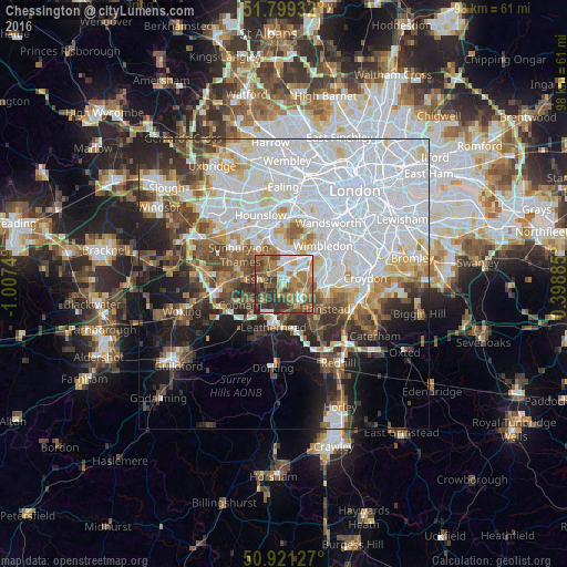
Analysis of Chessington night lights 2016
Square area 10x10 km:
 9.8%
9.8%90-99
11.9%80-89
4.62%70-79
7.7%60-69
20.59%50-59
13.17%40-49
11.2%30-39
14.01%20-29
7%10-19
0%0-9
0%Square area 50x50 km:
22.09%90-99
11.25%80-89
4.19%70-79
4.07%60-69
4.57%50-59
5.05%40-49
5.65%30-39
5.08%20-29
6.47%10-19
9.68%0-9
21.92%Clear (daylight) street map image can be seen on geolist.org.
Map coordinates:
51° 47' 57.6" North, 1° 0' 26.6" West
51° 21' 44.6" North, 0° 18' 15.4" West
50° 55' 16.6" North, 0° 23' 55.9" East
Some cities around Chessington sort by population:
• Esher
4.4 km =2.7 mi,  280°
280°
• Ewell
4.1 km =2.5 mi,  110°
110°
• Surbiton
3.3 km =2.1 mi,  7°
7°
• Epsom
4.3 km =2.7 mi,  146°
146°
• Hook
0.6 km =0.4 mi,  346°
346°
• East Molesey
5.1 km =3.2 mi,  322°
322°
• Worcester Park
4.6 km =2.9 mi,  64°
64°
• Thames Ditton
3.9 km =2.4 mi, 321°
2653229 (p: 19,433)
Sources (retrieved 2019-11-25):
» Earth at Night: Flat Maps 2012, 2016